
Hunter Geography Alumni Focus
Lynn Seirup (MA 2004)
Director of Public Safety GIS Data Development Center,
NYC Office of Emergency Management
|
|
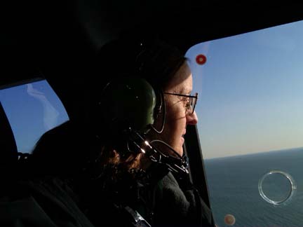
Lynn A. Seirup aboard a U.S. National Guard flight videotaping damage from Superstorm Sandy on November 9, 2012. |
Variety is the best part of my job. When I started working at the New York City Office of Emergency Management (OEM) as an intern, I looked at how to allocate the city's populations between temporary vaccination centers in the event that an epidemic threatened the city. Most recently, I've been using a new storm surge model from the National Hurricane Center to redraw the city's evacuation zones.
As Director of the Public Safety GIS Data Development Center at OEM, my mission is to acquire or develop the geospatial data sets needed to prepare for, and respond to, any emergency. My group responds to specific requests, such as "Where are there live animal markets in the city?" or "What languages are likely to be spoken in this area?" We also try to anticipate what might be needed. We work on data sets that might never be used, but then again, might become critical to a specific response effort. We develop contacts with GIS colleagues at other city agencies; state and federal entities; university research groups; and private companies, like the utilities. These relationships allow us to find the data we need and facilitate data sharing during a disaster.
While I may spend all day working on a data set, my life can change quickly if something happens and we go into response mode. I was about to leave the office one evening in 2007 when I received an email from OEM's 24-hour Watch Command reporting a steam pipe explosion near Grand Central Terminal. Fifteen minutes later I was headed uptown in OEM's Mobile Data Center with lights flashing and sirens blaring. I spent the night collecting information at the scene and creating maps for the field response. On Saturday afternoon, October 27, 2012, I arrived at the office to start a night shift in the Emergency Operations Center, which had been activated to coordinate the city's response to Hurricane Sandy. By the time I got home again on Wednesday, I'd done many maps, supplied local data to FEMA, answered a lot of questions, had a late night phone call with the Director of the National Hurricane Center, and briefed the Mayor on the city's storm surge risk. OEM's GIS group was central to the response effort, with over 1000 requests for maps and data.
My course work at Hunter prepared me for my current job in many ways. The most obvious benefits come from the GIS and programming skills developed in my GTECH classes. But equally important has been an understanding of environmental modeling, knowledge of population dynamics and the immigrant experience, and an appreciation for how urban areas develop and function. GIS skills might get you the job, but geographic thought and theory will help you use the skills wisely.
Published: May 20, 2013