Hunter Geography Alumni Focus
An Interview with Erika Jimenez, MA, Geography, 2018
By Christina Santiago, Hunter College, English major
|
|
Erika Jimenez uses geospatial technologies to understand the socio-environmental impacts of urban expansion in Guayaquil, Ecuador. Erika received an MA in Geography from Hunter College and was the 2018 recipient of the Hunter Society of Woman Geographers (SWG) Fellowship awarded to outstanding female graduate students in support of completion of her MA thesis and to encourage further graduate studies in geography.
What is your current research?
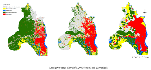
My thesis is about the analysis of socio-environmental issues caused by the urban expansion from 1990 to 2010 in the city of Guayaquil, Ecuador. The main objective of my research is to identify and quantify social and environmental impacts produced during this period using GIS and remote sensing tools. It develops a model which incorporates census data and land cover data using ArcMap, ENVI, and Python. Moreover, a historical, social and political research is developed in order to understand the dynamics of expansion in the Latin American city. Guayaquil, as many cities in Latin America, experienced a rapid and unplanned urban growth which caused social and environmental repercussions. Therefore, the purpose of this study was not only to identify and quantify the impacts but also to evaluate the political dynamics behind these issues. To sum up, this study develops an integrated research which combines historical and political literature with geospatial technologies to understand the socio-environmental impacts of the urban expansion.
What does geography mean to you?
For me, geography means a location with attributes. From this simple definition, we can expand our knowledge. For example, a location can be a forest or a city, and their attributes can be wildlife, deforestation, population, urban sprawl, etc. When I think of geography, a map always comes up in my mind, but what we can learn from that map is what geography really is. The analysis that we do, the techniques that we develop in order to understand the attributes or dynamics of a location is what I understand geography is.
Why is using a geographic approach so important to your research?
The geographic approach is relevant to my research because in order to analyze the impacts of urban expansion in Guayaquil, I needed to understand the spatial attributes of the city and the socio-political dynamics. For my analysis, I used explicitly geographic tools such as HotSpot Analysis, Markov chains, and land cover maps. Likewise, I studied the dynamics of urban expansion in the Latin American region to understand the impacts in Guayaquil. Therefore, my research was based on a geographical approach where not only I used geographic tools such as ArcMap or ENVI, but I also explored geographic concepts such as urban political ecology and land cover change models.
How will you benefit from SWG support?
I will use the SWG support to keep working on my thesis project and for future applications to the PhD. I plan on continuing working with the analysis of urban expansion in Guayaquil and develop a model to simulate future urban expansion. With this project, I will apply to PhD programs in the States. I am considering a few programs, which include the Graduate Center CUNY, University of Illinois at Urbana Champaign, University of California Berkeley, and University of Wisconsin -Madison.
Published: August 2, 2018