Lab 00: Warm up (optional)
GTECH 73200/36100
Overview of the lab: Selection and Aggregation
(Optional Warm-up Exercise)
This exercise focuses on different approaches and techniques available in ArcGIS Pro to select and aggregate spatial data. This lab exercise probably does not offer anything that you don’t know. Instead, it helps revive some how-to memories and prompt you to revisit concepts in the unlikely case you get stuck at one place or another. For a few of you, it helps you make the transition to ArcGIS Pro from either ArcMap or ArcGIS online.
Datasets
In this lab you will use the dataset selection.gdb that is contained in a zip file with the same name. Note that it is better and even necessary to really unzip the zip file and get the .gdb folder, i.e., the ESRI File Geodatabase, on your drive. Do NOT directly use the gdb within the zip file.
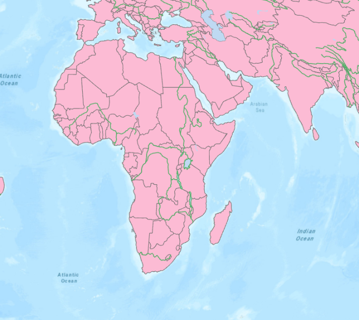
Add the following three layers to a new ArcGIS Pro Map: Country, Rivers, and Lakes. Set the map coordinate system or projection to the Mollweide projection (equal area projection) and zoom to Africa, which should look like the follows.
Learning Questions:
What is the “gdb” folder? Is it a regular folder where we can any data/files? Can ArcGIS Pro view and open the spatial data inside a gdb folder? What other software can we use to open and view the data inside?
What is ArcMap Pro project, map, and layout? Is the projection/coordinate system of an ArcGIS Pro map the same as the projection/coordinate system of the spatial data in the geodatabase (.gdb folder)? How are they different but related?
Attribute-based selection or Select by Attribute
In the layer Rivers find the river Niger. Open the attribute table of layer Country and select all countries where the average life expectancy of the population is less than 50 years (the value -99 stands for missing data).
Learning Questions:
Other than selecting features by Attributes in the opened attribute table, which query tool should we use to select features by their attributes? How can we exclude the countries with missing data (-99) in the query results?
Direct on-screen selection
In ArcGIS Pro, features can also be selected directly on the screen, e.g., using the Select tool you can select directly through a mouse click on the map.
Learning Questions:
Before selecting a feature, we usually need to check if the feature is what we intend to select. Which tool should we use to do that?
Location-based Selection or Select by Location
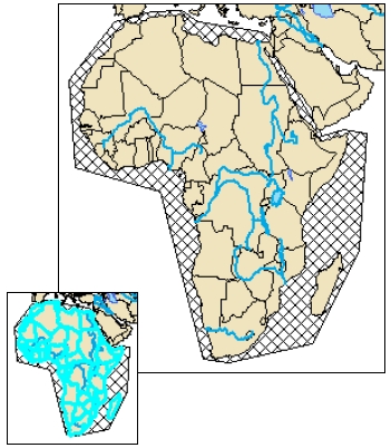
- Create a new polygon layer Selection_Africa that defines the spatial extent of the area under investigation (see figure below). For this you need to create a new Feature Class Selection_Africa in your geodatabase and digitize the corresponding circumlocutory polygon around Africa. Note that we just need the approximate extent, for learning purposes.
Hint: In Catalog, Right click on the geodatabase, then new Feature Class. In Edit menu, Create (Features). Use the polygon template.
- Select by location all countries that lie within this polygon (ignore fuzziness in the boundary areas like Atlantic islands).
Learning Questions: When open the “Select by Location” tool, what are Input Features and Selecting Features? Check out and think about those Relationships used to select features. Most tasks of the lab will use one or more of these spatial relationships.
Export the selected objects as a Feature Class Africa and add them as a new layer. For the exported dataset use the coordinate system of the original data set (geographic.) and not that of the Map (Mollweide).
Select all the objects in the new layer Africa to dissolve them into a single polygon and save the result (try to run it from Geoprocessing tools).
Open the attribute table of this new dissolved polygon. Which basic conditions like the types of data would have allowed the attributes to be aggregated accordingly (e.g., mean values for percentages, sum of absolute values, etc.)?
Selection by neighborhood
Select the country South Africa and its neighboring countries, i.e., countries that “touch” or share boundaries with South African, and calculate the total population size of that region. Note this is your second answer of your lab submission.
Selection by distance
Select all the countries that lie within 500 km from Lake Victoria. Pay attention to different options for such a selection like completely within, etc. Submit a list of the countries selected together with a description of the step that you took to arrive at this list.
Selection by intersection
Select again the river Niger and then all countries this river touches or goes through. What is the total population size of all selected countries?
Use the layer where Africa is a single polygon. Use this layer as a criterion to select all the rivers in Africa. Which operator did you use to solve this problem?
Map Visualization and Layout
Symbolize the African countries using the life expectancy (LIFEXPCT) field.
Create a map layout (letter size, portrait landscape) from the choropleth map. Add title, legend, scale, and other necessary map elements.
Export the layout to a high resolution (600 dpi) image in PNG or JPG format.
Reclassification and aggregation (a challenge to yourself)
Classify the objects in the layer Country according to the average life expectancy of the population into five groups. Compute the mean value of the attribute SAFEWATER for each of the classes (It is the percentage of the population having access to safe drinking water). Attention: the mean values are related to the African countries only. It is recommended to use the function Summarize for statistical analysis and aggregation respectively of the life expectancy values per class. Create a diagram to depict the classification. How do you deal with the value -99 and how do you make a decision about an appropriate classification?
Hints: This is a relatively challenging task. You are NOT expected to accomplish this, although some exceptionally good ones will. There are many different paths to the final solution. You can use symbology and visually set the groups. You can also use the “Multivariate Clustering” tool to do the classification, which also considers spatial relationships. Either way, multiple steps are likely to be required. And you also need to create new fields during the process.
Try to answer the following four questions:
Which countries lie on the equator (create a polyline for this selection)?
Which procedure results in selecting all the landlocked African countries?
What is the average population size of the countries selected in the above question?
How high is the lowest life expectancy in all the countries within 200 km from the river Zambesi?
Although this lab is optional, you can collect all your answers and descriptions of how you arrived at them (including the screen shot of the diagram of the safe water access task) and submit them as a single Word file to Blackboard, at the same place where you downloaded these instructions from.