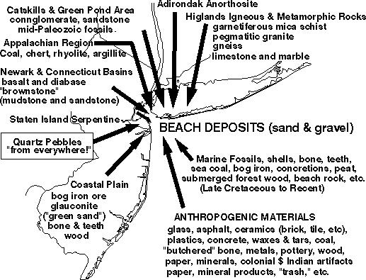
The coastal areas of the New York Bight are among of the most geologically active areas on earth. This might sound strange, but it is true (especially if you consider humans as geologic agents). Other critical factors affecting the dynamics of the area include the ongoing effects associated with the melting of the great ice sheets at the end of the last Pleistocene glacial advance (which ended as recently as about 10,000 years ago). The melting of ice has caused a great transgression of the sea. In addition, the removal of the weight of the ice (perhaps a mile or more in places) is causing the land to isostatically rise (in some areas more than others). This isostatic adjustment of the crust may be a trigger mechanism for many of the small earthquakes that have occurred in the region through time.
An enhanced portion of a Landsat image (below) includes parts of Brooklyn and Queens. The scene illustrates many features typical of the coastal region of the New York Bight region.
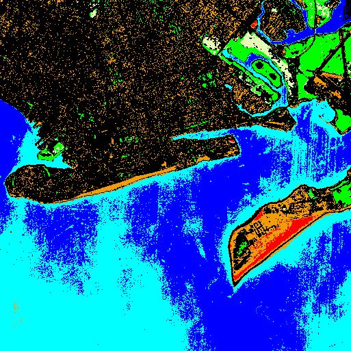
The image shows Rockaway Beach and Breezy Point (Queens, NY) on
the lower right. The entrance to Jamaica Bay separated the eastern end of the
Rockaway barrier island/spit from the urbanized southeastern portion of Long Island
(mostly southeastern Brooklyn). The beaches of Coney Island (lower center) and
Seagate (lower right) form a spit that projects eastward forming a protecting barrier
to the lower Hudson River Harbor (lower right). The image has been enhanced to
highlight certain features.
The geologic history of the area is perhaps best summarized by
following an outlined description of the physiographic provinces
of the New York Bight region. There is a reason for this: the
rocks underlying each physiographic province share a generally
"common" geologic history relating to both their origin and the
geologic forces that have since moved or altered them. The
physiographic provinces discussed here include:
The collection of web pages discusses the dynamic geologic
processes that control the development of modern coastal
landforms, and contains a collection of image libraries of area
shore features and specimens of natural and anthropogenic
materials from area beaches.
Hey, all you beginners... Click on the "geologic history" in the beginning of this page. You'll get an overview of some of the basics of geology...
 Return to the
New York Bight Home Page
Return to the
New York Bight Home Page
Phil Stoffer and Paula
Messina
CUNY, Earth & Environmental Science, Ph.D. Program
Hunter College, Department of Geography
Brooklyn College, Department of Geology
In cooperation with
Gateway National Recreational Area
U.S. National Park Service
Copyright September, 1996
(All rights reserved; use as an educational resource
encouraged.)>