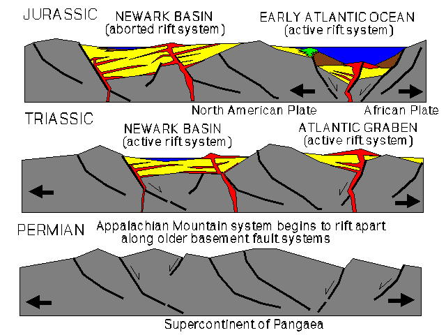
The great supercontinent of Pangaea held together for nearly 100 million years. Starting around Late Triassic time (about 220 million years ago) Pangaea began to break apart. A great rift system developed along the suture zone between the continents of Africa and North America. This expanding rift would eventually become the modern Atlantic Ocean. The complex rift system probably had characteristics similar to both the modern East African Rift Valley and the Great Basin region of western North America, consisting of multiple block-faulted uplifts adjacent to graben-type valleys with a scattering of volcanic centers. Triassic uplifts and grabens formed all along the Atlantic Margin from Alabama to Newfoundland. Whereas multiple graben valleys formed between the continents, only one continued to widen to eventually become the Atlantic Ocean. The other valleys became "aborted rifts," filling completely with lacustrine and alluvial sediments, and with both intrusive and extrusive mafic volcanic rocks (chiefly diabase and basalt).
The Newark Basin (in New Jersey and Pennsylvania) and the Connecticut River Basin are both "aborted rift" basins (rift basins that are no longer actively widening via rift-style tectonism - see map below). Both basins contain characteristic sedimentary sandstones and mudrocks that usually bear a red or brownish appearance from an abundance of iron oxide minerals (hematite and limonite). (Homes built of stone from the Newark Basin are called "brownstones.") Fossils are not abundant, but early Mesozoic dinosaur skeletons and trackways have been found. Freshwater shell material and poorly preserved fish and plant remains are also found in some areas.
Both the Newark and Connecticut river basins contain "traprocks." Traprocks are mineral-rich mafic volcanic rocks. Their resistance to erosion (relative to the surrounding sandstone and shale produce elevated regions above the surrounding terrain. They form the core of gently dipping cuestas throughout the Mesozoic basins along the Atlantic Margin. The volcanic rocks formed in three ways:
Lava flows interfinger with sandstones and mudrocks that were deposited in fluctuating lakes, quite similar to lakes that exist today in the Great African Rift valley in western Africa. The modern African rift zones serve as an excellent analog to the processes that created the Newark Basin.
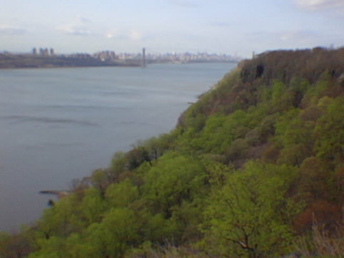
Through Triassic into early Jurassic time sediments accumulated in the broad Newark rift valley, burying the broken and eroded surface of the Piedmont region. Along the western side of the Newark Basin a great fault system marks the western side of this ancient valley/basin. The largest of these, the Ramapo Fault, forms the western edge of the Newark Basin trending northeastward across northern New Jersey into New York. (A fun note: the Indian Point nuclear power plant along the Hudson sits nearly on top of this ancient fault.) This fault is responsible for the escarpment between the sedimentary terrain of the Newark Basin and the ancient rocks that rise on the western side of the fault in the Atlantic Highland.
While the Newark Basin was forming sediments were carried into the valley by streams (possibly intermittent streams during times of desert-like climate conditions). The sediments were deposited on alluvial fans and on shallow water deltas the spread from the surrounding upland areas into lakes that grew and shrank with changing climatic conditions. Volcanism occurred intermittently, both as intrusions in the subsurface and flows on the surface. Through time sediments accumulated to great depths. Today as much as 11,000 feet (or more) of sedimentary rock and volcanic material of Newark Basin probably exists beneath the western side of the basin.
Whereas the Newark Basin rift system became inactive in Jurassic time, the Atlantic Basin continued to grow wider, eventually becoming the Ocean Basin as it exits today. In the early stages of marine flooding in Latest Triassic time the Atlantic Basin was probably similar to the modern Red Sea. The margin of the widening ocean basin probably developed large fringing reefs. However, as the region began to become more humid from the influence of the widening ocean basin, and as river systems began to develop along the coastal margin, the reefs eventually were smothered by an ever increasing supply of clastic sediment. Today the Baltimore Canyon Trough, a great sedimentary basin that parallels the trend of the continental shelf. The Jurassic reefs existed along the ancient continental shelf, the edge of the North American continental block adjacent to the deeper water of the Atlantic Ocean region. The reef are currently buried beneath many thousands of feet of Cretaceous, Tertiary, and Quaternary sediments.
The ridges of resistant volcanic rock of the Palisades and the Watchung Mountains display steep escarpments on their eastern flanks and gentle slopes on their western flanks. This is an indication of the gentle dipping character of the strata towards the deeper western side of the basin. When the sediments were originally deposited there were probably very nearly flat-lying. The structural dip of the rock probably developed through time as the basin continued to grow with the passage of time, even long after the youngest sediments of the basin were deposited. Mesozoic basins exist all along the eastern margin of North America. They may have been continuous or intermittently connected through time, similar to the basins in the Great Basin region of the western United States, however, late Mesozoic and younger structural changes and erosion has stripped away much of these deposits. The Newark and Connecticut River basins were probably part of the same large structural and sedimentary basin.
The sedimentary rocks of the Newark Basin are subdivided into three thick formations: the Stockton, the Lockatong, and the New Brunswick formations, oldest to youngest, respectively.
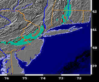
Newark and Connecticut Basin Rocks. (Portrait USA Map presented with permission from the American Geological Instutute, Joint Educational Initative Group.)
 Return to the
New York Bight Home Page
Return to the
New York Bight Home Page
Phil Stoffer and Paula
Messina
CUNY, Earth & Environmental Science, Ph.D. Program
Hunter College, Department of Geography
Brooklyn College, Department of Geology
In cooperation with
Gateway National Recreational Area
U.S. National Park Service
Copyright September, 1996
(All rights reserved; use as an educational resource
encouraged.)>