To convert a
As you make the cell size smaller, more
points are interpolated and the output raster resembles the input
A TIN’s
slope and aspect values can also be converted to rasters.
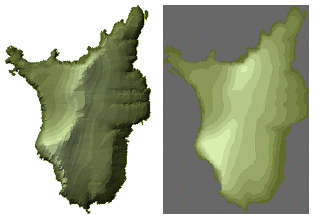
Left: A 2D view of a
![]() Are TINs better than rasters?
Are TINs better than rasters?
No, just different. TINs and rasters both have their advantages. Some of the advantages
of TINs are:
·
The
model has variable resolution. A
·
You
can refine the surface topography with polygon and line features, representing
roads, rivers, lakes, ridgelines, or other distinctive formations.
·
Because
TINs are vector data, they display well at all zoom
levels. Raster display degrades when you zoom in too close.
·
For
large-scale applications (those covering a small area in detail) or
applications where display quality is very important, TINs
are often a better choice.
On the other hand, rasters have
their advantages, too:
·
Their
matrix structure makes them well-suited to analysis. Many more mathematical and
statistical functions are available for rasters than
for TINs.
·
They
demand fewer system resources. They can be created and displayed more quickly
and take up less disk space.
·
They
are a more familiar and readily-available data type.
·
For
small-scale applications (those covering a large area), or applications that
require statistical analysis of data, rasters are
often a better choice.