Lambert Azimuthal Equal Area
You have
probably already guessed that the Lambert Azimuthal
Equal Area map projection was invented by Johann Lambert and that it maintains
direction and area. It was Lambert's last major projection (1772).
Occasionally, it is simply called the Zenithal or Azimuthal
projection.
It is used extensively for the polar regions, but it can be used for hemispheric applications as well.
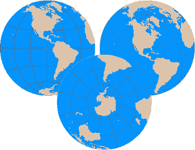
Here are three examples of the Lambert Azimuthal Equal Area projection. The upper left is an equatorial, the upper right an oblique, and the bottom, a polar aspect.
The center of the projection is the only point with no distortion. Scale decreases outward in a radial pattern from the center. Direction is true for the polar aspect, which is the only aspect of the projection to which the term "azimuthal" truly applies.