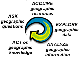
The geographic inquiry process: a way to problem solve
When
solving problems with
|
Step |
Description |
|
1. Ask
a geographic question |
Develop
geographic questions that need to be answered such as, "What is the
pattern to when and where crime is occurring?" |
|
2.
Acquire geographic data |
Obtain
the geographic data you need from a company database, the Internet, other
sources, or create it yourself. |
|
3.
Explore geographic data |
Create
a map of your geographic area and symbolize data. |
|
4.
Analyze geographic information |
Determine
problem-solving approach and perform |
|
5. Act
on geographic knowledge |
Develop
your message and intended audience and create visuals to communicate
information. |
If you
take a close look at the structure of this course, you'll see that the modules
follow the geographic inquiry process. Most exercises also follow this process.
It's a common-sense approach to solving problems with
Depending on the type of problem you're trying to solve, the geographic inquiry process can be iterative. In some cases, the last step of the geographic inquiry process leads to more geographic questions and the whole process begins again.