Geoprocessing in ArcGIS
ArcGIS
comes with hundreds of geoprocessing tools. The exact
number of tools you have depends on your software license. You can view and
access your available geoprocessing tools in both ArcToolbox™ and the ArcCatalog™
Catalog tree.
Individual geoprocessing tools are organized into toolsets. Toolsets are stored in toolboxes. There is a toolbox for all the major categories of geoprocessing operations, such as analysis, data conversion, and data management.
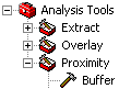
Analysis Tools is a toolbox containing three toolsets: Extract, Overlay, and Proximity. The Proximity toolset contains the Buffer tool.
You can create your own tools and store them in one of the existing toolboxes, in a folder on your local disk or network, or even inside a geodatabase. If you want to organize the tools you use most frequently or the tools needed for a particular project, you can create a custom toolbox to store them all in one place.
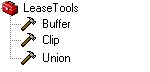
You can create custom toolboxes to store all the geoprocessing tools needed for a project in one place.
The ArcGIS Desktop Help can help you figure out which tool you need for a particular task and tell you how to use it. Both ArcToolbox and ArcCatalog provide search tools to help you quickly find the geoprocessing tool you need.