The geoprocessing process
During a
GIS analysis, geoprocessing operations are performed
in a particular order to achieve a final result—a dataset that contains the
features and attributes of interest for the analysis. In ArcGIS you perform geoprocessing operations using geoprocessing
tools.
A geoprocessing tool performs an operation on an input dataset and creates an output dataset. The output of one geoprocessing tool is often used as the input for another geoprocessing tool. A dataset that is produced as an output of one tool and then used as an input for another tool is called intermediate data.

A geoprocessing tool performs an operation on an input dataset and produces an output dataset.
A geoprocessing tool requires certain parameters in order to
perform its operation. Tool parameters consist of the name and location of the
input dataset, values specific to the geoprocessing
operation (for example, a buffer distance), and the name and location of the
output dataset.
In the last module, you used workflow diagrams to organize and plan the individual parts of an analysis. Workflow diagrams often show geoprocessing operations, as the one below does.
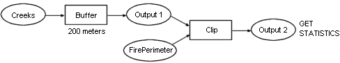
A workflow diagram helps with planning the order of the geoprocessing operations used in an analysis. Workflow diagrams show which geoprocessing tools are being used, the data produced by each tool, and the order in which the tools are used.
In a
typical analysis that includes geoprocessing
operations, you would follow the steps below:
1.
Determine
which geoprocessing tools you need.
2.
Determine
the order in which the geoprocessing tools should be
used.
3.
Locate
the first tool and open its dialog.
4.
Enter
the tool parameters, including the input and output datasets.
5.
Run
the tool.
6.
Repeat
steps 3-5 for each geoprocessing tool in order.
7.
Examine
the final output and repeat some or all of the analysis steps as needed.