Geoprocessing for analysis
When geoprocessing operations are used for analysis, they create
new data that can be used to answer geographic questions such as, "How
many customers live within a certain distance of my store?" or "Which
property owners will the street widening project affect?" ArcGIS provides
a variety of geoprocessing tools for finding the
answers to these and many other questions.
Geoprocessing tools used for analysis typically fall into three categories: data
extraction, overlay, and proximity.
Data extraction
Data
extraction means creating a new subset of features in one feature class based on
the geographic extent of another feature class. Suppose you want to analyze
snowy owl nesting sites within a national park in
With an operation called clip, you can use the boundary dataset to extract, or clip out, the nesting site features that fall within the extent of the park into a new dataset. These are the features of interest for your analysis, and reducing the size of the dataset you're going to use will reduce processing time down the road. The software won't have to consider all the other nesting sites in the state.
In a clip operation, a clip layer is overlaid like a cookie cutter on top of an input layer. The input layer's features are clipped to the extent of the clip layer.
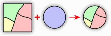
Overlay
If the
data you need to answer a specific question is contained in different layers,
you can combine, or overlay, the layers to create a new layer that contains the
data from both input layers. For example, suppose you have layers of parcels
and city zoning areas. The parcels layer contains owner names. In order to find
the names of all the owners of commercial property, you could overlay the two
layers using an operation called union.
The dataset created by the union operation contains all the features and attributes from both layers. You could quickly query the new layer to find the commercial property owners. You performed a union in Module 1 as part of the analysis in which you identified potential buildings for a youth center.
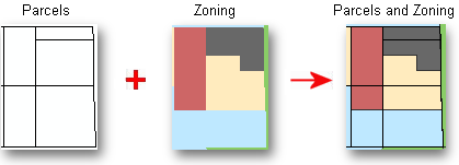
A parcels layer is overlaid with a zoning layer. The overlay operation creates a new layer with features and attributes from both the parcels and zoning layers.
Proximity
A common type of GIS analysis, called proximity analysis, involves finding what is near or within a certain distance of one or more features. Buffer is a common geoprocessing operation used for proximity analysis. For example, if you want to notify parcel owners about a new bus stop that is within a certain distance of their property, you can use a buffer operation to find all the parcels within that distance. As you saw in the Module 1 tornado exercise, a buffer creates a zone of a specified distance around one or more features.
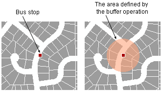
In this example, a buffer has been created to define the area within a certain distance of the bus stop.