Spatial modeling
Models abstract and
simplify complex systems in order to make them easier to understand. Many types
of models are used in
A
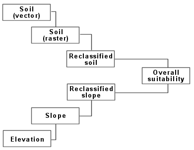
Here a soil raster was created from a soil vector layer
and a slope raster was derived from an elevation surface. Both were
reclassified to a common scale and then combined into a map of suitable
locations.
In a broad
sense, a model is a filter that helps extract information from volumes of
complex data. For example, as a farmer you may decide where to apply fertilizer
on your crop based on previous harvest yields, soil moisture, and soil pH.
The level of difficulty
depends on the nature of the problem. Some models (e.g., finding conflicts
between a general plan, zoning restrictions, and actual land use) are quite
simple, requiring only a day or so to design and implement—provided you
have the data, of course. Other models (e.g., siting
a nuclear power plant) may require many months to design and implement. Because
models often require specialized knowledge, they are typically a team effort.
It is important to note
that your model is only as good as your data, your design, and your
implementation. While you will always have to contend with some amount of
errors in your data, with proper planning and some simple skills, you should be
able to minimize errors in design and eliminate errors in implementation.
Regardless, your model is
an abstraction of reality, so error will always be present. Models, however, do
provide you with a way to better understand a problem and to test alternatives.