The
Neighborhood Statistics function
The Neighborhood Statistics
function helps you discover trends within a single
raster dataset based on the values within a specified group of cells, which
surround and usually include the evaluation cell. This technique is like
passing a filter over your data and can be used to indicate diversity of
feature types or to impose neighboring values over existing values.
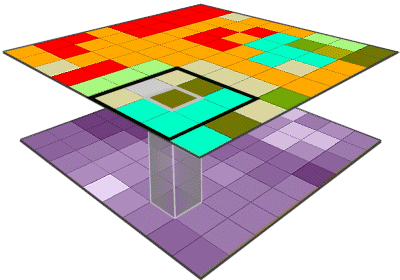
With a 3-cell by 3-cell neighborhood, the evaluation cell
is located in the center of the neighborhood.
Statistics
are determined based on the cells in the neighborhood. The corresponding cell
in the output raster is given the resulting statistical value. The neighborhood
passes over every cell of the input raster, left to right, top to bottom, until
all of the cells have been processed.
You determine the size and
shape of the neighborhood. For example, you can use a rectangular neighborhood
of any dimension.
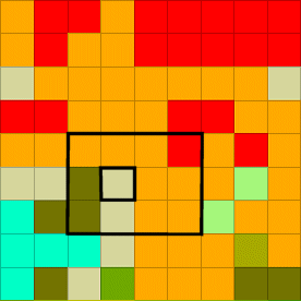
If an even number is used in the x-direction of a
rectangular neighborhood, the center cell will be to the left of the true
neighborhood center. If an even number is used in the y-direction, the center
cell will be above the true center of the neighborhood
Alternatively, you can use
other neighborhood shapes, such as a circle, an annulus (a doughnut shape), or
a wedge.
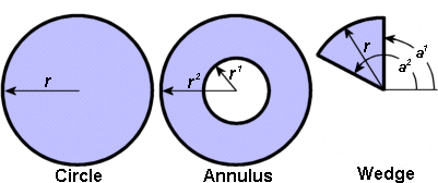
This graphic illustrates the processes involved in
specifying any of the three types of circular neighborhoods.
A circular
neighborhood is specified by giving the radius of the circle in the number of
cells measured perpendicular from the x- or y-axis.
The annulus or donut
neighborhood requires two radii. The first specifies the number of cells to the
inside of the donut and the second, the number of cells to the outer edge. Only
cells that fall between the two radii will be considered.
The wedge or partial circle
is specified by identifying the radius of the circle and two-degree bearings
that define the slice of the circle for the neighborhood. The smaller degree
reading must be specified first, and only the cells between the two degree
readings will be considered when processing each cell. Zero degrees is to the east and 90 degrees is to the north; the bearing
increases counterclockwise.
If you don’t specify
a neighborhood shape or size, Spatial Analyst uses the default, a 3-cell by
3-cell rectangular neighborhood.