Example: Creating a terrain surface with sample
points
ArcGIS™ Spatial Analyst makes it
easy to interpolate any type of surface from a set of sample points.
Interpolation methods such as Inverse Distance Weighted (IDW) depend on good,
quality sample point sets to function properly. For ths
reason, you should pay attention to spacing and density when assembling a set
of sample points.
Take a look at an area on
the southern tip of the Shivwits Plateau in
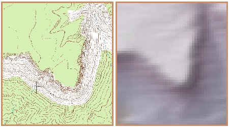
Left: A 7.5'
Travertine Rapids topographic map of the Shivwits
Plateau. Contours help represent the features and characteristics of the
landscape. Right: A surface, 30-meter digital elevation model (DEM) for the
same quadrangle. At this scale, you can just see the 30-meter square cells of
the raster surface.
For this
example, suppose the digital elevation model above does not exist and it's your
job to produce it. The only tools you have to create it are your ArcGIS™ software and this digital raster graphic
(DRG) of the Travertine Rapids topographic map (left). Lucky for you, that's
enough to interpolate a point layer.
First, you need to create
enough points to make interpolation worthwhile. Using the contours on the
topographic map as a guide, you digitize points and
record the elevation values for each location. As you digitize, you make sure
to distribute the sample points as evenly as possible throughout the area,
placing fewer points on the plateau where it's fairly level, and putting more
points in places where the contour lines are closer together.
Once you have created an
initial set of sample points, you use the IDW function to interpolate the
surface.
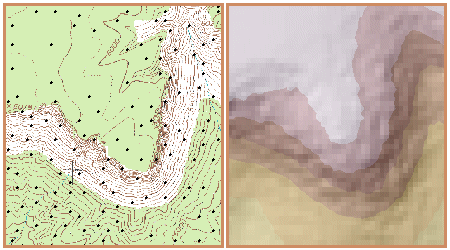
Left: The black dots on the topographic map are the initial sample point set. Based on the elevation values assigned to each sample point, the IDW function will estimate the elevation values between the points. Right: In this case, the resulting surface is a continuous raster with 30-meter cell size.
IDW does a good job of estimating
the surface with only a limited number of sample points, but when compared to
the topographical map, you can see that there is detail missing. You need more
sample points.
Using the same method as
before, you supplement the sample point set with more points, then run IDW again.
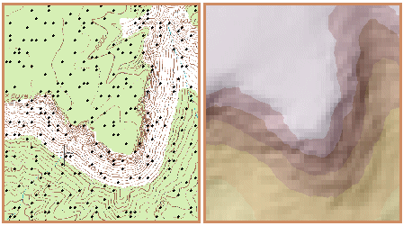
More sample points help the IDW function refine the surface
estimation.
Now the plateau, steep cliffs, and
variations in the terrain are more apparent. Encouraged by these developments,
you continue building the density of sample points and run IDW again.
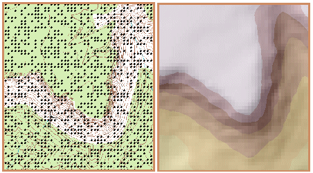
Left: Notice that this dense set of sample points is made up of clusters of evenly spaced points. Right: In the resulting surface, features such as the plateau, the cliff faces, and the steeply sloping landscape are distinguished from each other.
You notice that the more sample
points you add, the more accurately the digital surface represents the actual
terrain. Remember that the elevation values for each point must be derived from
somewhere (e.g., contour lines or field observations). If you had the data and
the time, you could create a sample point set for this area from thousands of
points at regularly spaced intervals. But you don't have either, so this
surface will have to do for now.
From this example, you can
see that a surface interpolation function like IDW depends heavily on the
quality of the sample point set. The quality increases as the point set becomes
sufficiently dense to capture subtle and dramatic changes in the surface.