Contours
A contour is a line
connecting points of equal surface value. Contour lines reveal the rate of
change in values across an area for spatially continuous phenomena. Where the
lines are closer together, the change in values is more rapid. Elevation and
barometric pressure are commonly mapped using contours.
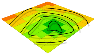
Contour lines can be
used to represent surfaces. A contour line is a line following an equal value.
Contour
lines are drawn at an interval that you specify. The interval is simply the
change in z value between the contour lines. For example, a contour map of
precipitation with a contour interval of 10 inches would have contour lines at
10, 20, 30, and so on. Each point on a particular contour line has the same
value, while a point between two contour lines has a value that is between the
values of the lines on either side of it. The interval determines the number of
lines that will be on a map and the distance between them. The smaller the
interval, the more lines will be created on the map.
You can also specify a base
contour, which is a starting location. A base contour is not the minimum
contour, but refers to a starting point from which contours go both above and
below, based on the contour interval. For example, the base contour may be set to
0 and the interval may be set to 10. The resulting contour values would be -20,
-10, 0, 10, 20, and 30.
Contours can represent many
types of data. Lines connecting surface or sample points of equal value are
known as isolines. The following are all examples of
different types of isolines:
- Isobar: Equal barometric pressure
- Isochron: Connecting lines of equal
time
- Isohel: Equal duration of sunshine
- Isohyet: Equal rainfall
- Isoseismal: Earthquake shock intensity
- Isotherm: Equal temperature
- Isogonic: Equal magnetism