The Cell Statistics function
You can use the Cell
Statistics function to find trends or detect change between corresponding cells
in multiple raster surfaces. The assessment works exactly like the mathematical
operators in the Raster Calculator, such as multiplying or adding raster datatsets together.
In this case, however, the
function uses one of the statistical methods mentioned previously to compare
the corresponding cells. For example, you can create a raster with cell values
indicating change from one land use type to another.
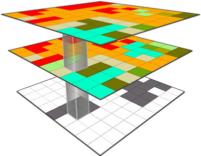
In this example, the middle layer was developed three
years before the top layer. In the resulting raster, the gray cells indicate
where more than one land use value has occurred. The Cell Statistics function
is like sinking an elevator shaft through the matching cells of each raster
dataset.
Monitoring change in the
landscape is a way of discovering trends in urban development, habitat loss,
and crop management, for example. To monitor the
change in the landscape, you need snapshots of the data for an area that show
the area's conditions at different points in time. Once you have the snapshots
you can compare them using the Cell Statistics function to see where changes
have occurred.