Z-values
A z-value stored for a given
location represents an attribute other than that location’s horizontal
position. For example, the longitude and latitude of a point can be stored
respectively as an x and y coordinate. The elevation of that same point would
be stored as its z-value.
The graphic below illustrates the
basis of 3D modeling—defining the x, y, and z dimensions of an object or
phenomena.
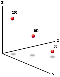
Each dot in the graphic is labeled
with its z-value, which, in this case, represents elevation. The x and y values
of the dots, which are not labeled, define their horizontal position.
In an elevation or terrain model,
the z-value represents elevation; in other kinds of surface models it
represents the density or quantity of a particular attribute. For example, the
cells of a raster surface could hold z-values that represent precipitation
levels.