Raster to
features
Raster
layers can be converted to polygon, point, or line features. Converting raster
data to features has the same purpose as converting
Raster layers should be reclassified
before they are converted to polygons. This generalizes the data and keeps the
output file from becoming too large. (You probably do not want a polygon layer
with half a million features in it.)
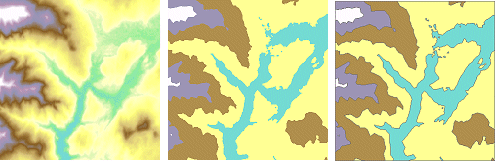
Left: An elevation raster. Middle: Reclassification of the
raster creates a new raster with five elevation classes. Right: The
reclassified raster has been converted to a polygon shapefile.
If you convert a raster to
points, the output file has a point feature corresponding to the location of
each cell center. If you convert a raster to lines, the output file has a line
feature corresponding to each cell edge.