Finding
steepest paths
As the name implies, this
technique is used to find the steepest path down a slope. Besides
its use for modeling the route a fluid will take down a slope (water flow, mud flow,
lava flow, etc.), it can also be used to estimate the accuracy of a surface.
For example, you can create a steepest path from the origin of an existing
stream then compare it to the actual path of the stream. Assuming the original
stream data is accurate, you can estimate the accuracy of your surface model
based on the deviation between the two paths.
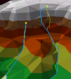
By comparing the steepest paths (yellow lines) with the
actual stream locations (blue lines) you can estimate the accuracy of this
surface model.