Fill
polygons
A fill polygon tags an area
with an attribute value so that the TIN
can be symbolized by this value. The attribute must be
an integer. Fill polygons are used to represent continuous surface features
like land cover and land use or discrete features like flood zones or
endangered species habitats.
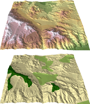
Top: A TIN
symbolized by elevation. Bottom: A continuous polygon layer of vegetation has
been added as fill polygons. The TIN
is symbolized by vegetation code.
Like other surface
features, fill polygons cause the TIN to be retriangulated.
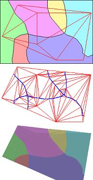
Top: The polygon layer will be added to the TIN as fill polygons. Middle: The TIN is retriangulated.
The blue lines, indicating polygon boundaries, become triangle edges. (They
look wavy, but they are straight line segments.) Bottom: The TIN is symbolized by the polygon attribute values.
 Tag values
Using fill polygons is not the only way to assign integer
values to triangle faces. You can also assign them by specifying a “tag
value” field from the attribute table when you add, replace, or clip
polygons.
You
can also assign integer values to triangle nodes by specifying a tag value when
you add mass points. Tag values cannot be used with breaklines
or erase polygons.