Creating 3D
features
3D features differ from 2D features
in that they store a z-value as part of their spatial definition. 3D features
can be created from scratch (you define a new feature class to be 3D when you
create it), or they can be converted from existing 2D features.
Since 2D features can already be
displayed in 3D, the main advantage of 3D features is one of convenience. If
you frequently add the same 2D layer to ArcScene, you
may get tired of setting its base heights every time. By converting it to 3D,
you no longer have to do this.
To convert a 2D layer to 3D, you
need the missing ingredient: z-values. There are three ways to get z-values:
·
From
a raster or
·
From
an attribute in the 2D layer attribute table
·
By
typing a value (which is then applied to all features in the 2D layer)
If the 2D layer is a point layer,
each feature gets a z-value. If it is a line or polygon layer, each feature
vertex gets a z-value.
![]() More about getting
z-values from rasters and TINs
More about getting
z-values from rasters and TINs
When
the source of z-values is a raster, the z-value assigned to each point feature
depends on the point’s location within a cell and the values of nearby
cells.
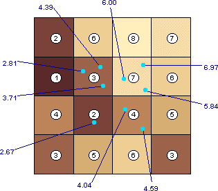
A point layer, symbolized in light blue, has been
converted to 3D using the raster as the source of z-values. The raster cell values are shown in white circles. The interpolated
z-values of the points are labeled in dark blue.
For
line and polygon layers, a z-value is interpolated for every feature vertex.
Additional vertices are created at intervals equal to the grid cell size.
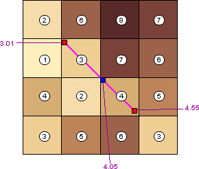
A line feature, symbolized in purple, is converted to 3D.
Z-values are interpolated for the original 2D line vertices (shown in red) as
well as for a new vertex (blue).
When
the source of z-values is a
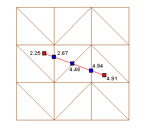
A line feature, symbolized in red, is converted to 3D.
Z-values are interpolated for the original 2D line vertices (red) and for three
new vertices (blue).
Digitizing 3D features
You can digitize 3D features in an ArcMap™ edit session if your map document contains a
raster or
The 3D digitizing tools (one for
points, one for lines, and one for polygons) are located on the ArcMap 3D Analyst toolbar.
Digitized 3D features have
a z-value for every vertex you digitize. Just like features that are converted
from 2D to 3D, they also have vertices at cell-size intervals (if you are
digitizing on a raster) or where features cross triangle edges (if you are
digitizing on a
A 3D polygon digitized on a