Implementing a geodatabase for local
government, Part 2
Preparing
the geodatabase for data editing
Recall
from the previous module that Sue, a GIS consultant from OMH Inc., is in the
process of implementing a pilot geodatabase for the
city of
At this
point in the project, Sue has determined the spatial references for the data
that will be stored in the pilot personal geodatabase.
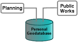
Initially, she had planned to create one personal geodatabase
with separate feature datasets for each of the participating city departments.
She is now considering additional database design issues:
- Certain datasets should be organized based on their
topological relationships to other datasets. For example, changes to the
polygon features in the city boundaries layer may affect the geometry of
certain features in the zoning and subdivisions layers. But having all
department datasets participate in the same topology may not be wise, as
making edits to one feature class can affect all other feature classes in
the topology. In some cases, the department may not want edits made to all
feature classes.
- The organizational structure represented by the city
departments is important, however. It is preferable that certain
departments have sole responsibility for maintaining certain datasets, and
other departments should be able to access, but not edit, that data. For
example, the Planning Department is responsible for the city boundaries,
subdivisions, and zoning layers, while Public Works is responsible for the
water and sewer system layers.
Sue could
go forward with her plan to store all the data needed for the pilot project in
one personal geodatabase, organizing topologically
associated data into several feature datasets and creating common, standalone basemap feature classes and nonspatial
tables. However, only one person at a time can edit data stored in a personal geodatabase, which could negatively impact the normal
workflow of the Planning and Public Works departments. It is also possible that
the required data might exceed the personal geodatabase
size limitation (2 gigabytes).
If only one department is using a
personal geodatabase, edit access can be limited to
specific staff. If more than one department has edit access to a single
personal geodatabase, conficts are more likely.
If Sue
were going to implement a multiuser geodatabase for the pilot project, the size of the geodatabase would not be an issue. She could also set
permissions to different parts of the geodatabase so
that each department had edit access only to the feature classes and feature
datasets for which they were responsible.
With a multiuser geodatabase, she could
create versions of the geodatabase which department
staff could check out, edit, then check back in. If
editing conflicts arose, each user or an ArcSDE®
administrative user would reconcile any differences in the versioned edits back
into the master geodatabase.
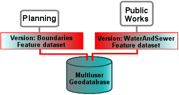
In a multiuser
geodatabase environment, different pieces of the geodatabase can be versioned. Editing permissions are
tightly controlled and all edits must be reconciled before becoming part of the master
geodatabases.
The city
is not ready to implement a multiuser geodatabase, however, and for the pilot project it isn't
necessary. Sue knows that she can migrate the data
from the personal geodatabase to a multiuser geodatabase after the
pilot project has been implemented and evaluated. She decides to create several
personal geodatabases that will be assigned to different city departments.
For the
Planning Department, Sue will create a personal geodatabase
named Planning and it will contain a feature dataset named Boundaries. The
Boundaries feature dataset will contain all the feature classes and
relationships having to do with subdivisions as well as all the feature classes
and relationships built on subdivision geometry, such as city boundaries and
zoning.
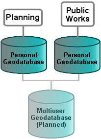
When a personal geodatabase
is created for separate departments or staff, a common structure with the same
spatial reference should be maintained. Components of the personal geodatabases
can be migrated to a multiuser geodatabase
at a later date.
Creating
personal geodatabases for each department will allow Sue to control access to
specific data and allow each department to manage the editing process.