What is Snapping?
Snapping
is used to create coincidence when editing features. The snapping process moves
a vertex of one feature to a location on another feature when the mouse pointer
comes within a specified distance called the snapping tolerance. For example,
if you want to snap a power line to a utility pole and the snapping tolerance
is set to 25 pixels, whenever the power line comes within a 25-pixel range of
the pole, it will automatically snap to it. The snapping tolerance can be
measured in either map units or pixels.
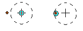
When the location being snapped to
is within the snapping tolerance (dashed circle), the snapping location (blue
dot) moves to the location being snapped to (orange point).
There are
three types of snapping properties you can set: layer snapping, sketch
snapping, and topology snapping.
With layer
snapping, you can specify whether features will snap to vertices, edges, or
endpoints for each layer. You can set layer snapping properties for all layers
in your map, whether or not they are editable layers. The graphic below shows
examples of vertex, edge, and endpoint snapping.
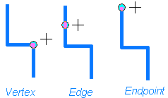
The three types of layer snapping.
Sketch
snapping properties are relative only to vertices and segments in your current
sketch, not to vertices and segments in other layers. You can specify that new
segments snap to lines that are perpendicular to your last segment or that new
vertices snap to existing vertices in your sketch.
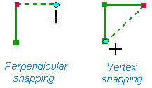
The two types of sketch snapping.
Topology
snapping properties are used to snap an element to a node in a topology. You'll
learn more about topology in the next exercise.
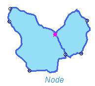
Topology snapping.
You set
snapping properties in the snapping environment window. In the top part of the
window, the order of the layers determines the order in which snapping will
occur. You can drag the layers up and down to reorder them. Sketch and topology
snapping properties are set in the bottom part of the window. If you are using
the ArcGIS Survey Analyst extension, you can also set snapping properties for
survey points.
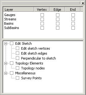
The snapping environment window.