Implementing
a geodatabase for local government
In an
effort to centralize spatial data access and streamline city operations, the
city of
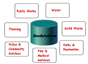
Many departments want to
participate in the geodatabase project. The city
plans to centralize storage of spatial data and will eventually reduce the
costs of maintaining it.
For its
pilot project, the city is creating a personal geodatabase
that will store some data from the Public Works, Planning, and Water
departments, the city's largest
Sue, a GIS
consultant from OMH Inc., is working on the pilot project for the city. To
create the pilot geodatabase, one of the first issues
she must deal with is defining the spatial reference of the datasets that will
be stored in it.
For the
spatial reference she needs to:
· Select an appropriate coordinate
system
· Review the default spatial domain
generated by ArcGIS
· Adjust the default spatial domain
as needed
When
deciding which coordinate system to use for the various feature classes in the geodatabase, Sue first investigated which one was being
used for most of the existing data. Because the city has a limited geographic
extent, selecting the NAD_1983_UTM_Zone 11N coordinate system for all feature
datasets and standalone feature classes is appropriate. For a continental or
global extent, data would have to be organized around a series of UTM zones.
For this geodatabase, the geographic extent of the different data
layers is similar but there is some growth planned around the southeastern city
boundary, which will need to be factored in within two to three months. Sue
checks the default domain values that are created when she imports the shapefile with the largest data extent. The default spatial
extent is large enough to accommodate the planned growth. The precision is also
more than adequate to support the data. This spatial reference will be used for
all feature datasets and feature classes.
Most of
the city's non-CAD data are in coverage format and the coordinates are stored
with double precision. When the coverages are
converted to geodatabase feature classes, the
coordinates will be stored in geodatabase precision.
Some ArcView® shapefile
data will also be converted to geodatabase features.
The transition from double precision to geodatabase
precision will result in a small change in precision, but will still be
accurate.
The city's
spatial datasets were collected at a scale of 1:1,200 and adhere to the
National Map Accuracy Standards. Sue is using a precision of 1 foot for the
water system data because it is important to get the exact location of the fire
hydrants and water valves for maintenance and emergency response workers. She
is organizing this data in a feature dataset called Water.
At a scale
of 1:1,200, the city's roads and parcel data must have a horizontal accuracy of
±4 feet. Sue is creating separate feature datasets for Roads and Parcels.

A view of the city's pilot geodatabase in ArcCatalog.
Sue has
scheduled some time for developing the metadata for each feature dataset and
feature class. This information will help users when they access the data. For
example, information on the coordinate system will help users know whether they
can display other data with a particular feature class.
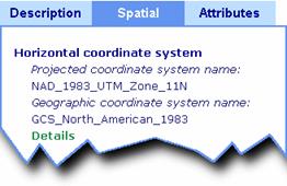
In ArcCatalog,
you can review the metadata for a feature class to get important information
about the data, including its coordinate system.
Now that
she's determined the spatial reference for all the datasets that will be stored
in the pilot geodatabase, Sue turns her attention to
the data migration plan. Public Works has many CAD drawings that it wants to
include in the project. ArcGIS provides an Import
from CAD tool that converts CAD data to geodatabase
feature classes. CAD text is converted to a point feature class. Parametric
curve information is retained on the CAD features as it is converted to the geodatabase. CAD geometric properties and block and cell
attributes can also be retained during the conversion.
For the
city's pilot project, Sue's most important task is to populate the geodatabase and make sure there are no problems. For the
remaining time of the pilot project, Sue will implement additional
functionality of the geodatabase. If I get my act
together, then you will see how the city's geodatabase
project progresses in the remaining lectures of this course.