Changing
the spatial extent
When you
create a standalone feature class or feature dataset, you can change the
spatial extent by manually entering new values for the minimum x and y
coordinates.
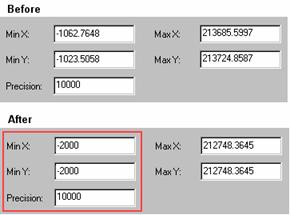
You can change the Min X and Min Y
values by entering new coordinates directly into the dialog. The Max X and Max
Y values update automatically to reflect the new minimum values. In this
example, the user is importing the spatial reference from another feature class
and changing the spatial extent to allow for data expansion to the west and
south.
If you
know the spatial extent that your data will require, you can simply enter the
appropriate Min X and Min Y values. You should check the updated Max X and Max
Y values to make sure they are equal to or larger than the maximum x and y
coordinates required for your data. If they are not, you will need to change
the precision to a lower value.
You can determine the required
minimum and maximum x,y
coordinates based on the minimum bounding rectangle for your data.
If you
don't know how large a spatial extent your data will require, you can center
your data in geodatabase coordinate space and
explicitly define your precision. This method would provide the maximum amount
of room for your data to grow in all directions.
![]() Centering your data: planning for unknown
growth
Centering your data: planning for unknown
growth
When you create a new feature class or feature dataset,
you may not be able to anticipate how large a spatial extent the data will
require in the future. The solution is to shift the geodatabase
coordinate space so that it is centered around your current data, thus allowing
for growth on all sides.
To shift the geodatabase
coordinate space, you need to calculate the difference between the middle of
your current dataset and the middle of geodatabase
coordinate space.
Consider this example: A source dataset with a Min X value
of 200,000; a Min Y value of 440,000; Max X and Max Y values of 1,000,000;
units of meters; and a precision of 1,000.
First, find the center of geodatabase
coordinate space in storage units:
2,147,483,648 / 2 = 1,073,741,824
Note: 2,147,483,648 is the largest integer
value that can be stored in a geodatabase.
Next, convert the center in geodatabase
storage units to map units by dividing by the precision:
1,073,741,824 / 1,000 = 1,073,741.824
The second part of the process is to find the center of
your current dataset:
(DataMinX + DataMaxX)
/ 2
(200,000 + 1,000,000) / 2 = 600,000
(DataMinY + DataMaxY)
/ 2
(440,000 + 1,000,000) / 2 = 720,000
Finally, calculate the shift by finding the difference
between the center of your data and the center of the geodatabase
coordinate space (in map units):
DataCenterX – GDBCenter
= X Shift
600,000 – 1,073,741.824 = –473,741.824
DataCenterY – GDBCenter
= Y Shift
720,000 - 1,073,741.824 = –353,741.824
In the Spatial Reference Properties dialog, enter the X
Shift value (–473,741.824) for the Min X value and enter the Y Shift value
(–353,741.824) for the Min Y value. This will shift the geodatabase
coordinate space to the left and down.