Spatial
extent
The
spatial extent is the allowable range for x and y coordinates (and for m and z
values if you have them). When you create a feature class or feature dataset,
the spatial extent is defined using minimum and maximum x and y coordinate
values.
The minimum and maximum x,y coordinates are determined by
the bottom left and top right corners of the bounding rectangle.
When
you're creating a feature class or feature dataset, ArcCatalog
will always provide you with either placeholder values or default values for
the spatial extent.
· If you select a predefined
coordinate system or create a new one, the values shown for the spatial extent
are merely placeholders which you will need to modify.
· If you import the spatial reference
from another geodatabase feature class or feature
dataset, the minimum and maximum x and y coordinate values are the same as the
source data.
· If you import the spatial reference
from a shapefile or coverage, ArcCatalog
provides default values for the spatial extent which it calculates by adding a
buffer to the source data extent. The buffer is a perfectly square area that is
some multiple of the larger side of the source data's extent (up to 10 times
its width or height) and is centered around the source
data extent. This buffer allows room for your data to expand.
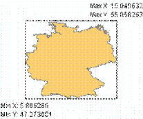
For example, when creating a feature dataset, if you
import the spatial reference for
The default spatial extent for a
feature dataset as calculated by ArcCatalog.
Once
a new feature class or feature dataset has been created, you cannot change its
spatial extent!