Choosing
a coordinate system
When you
create a new standalone feature class or feature dataset, you need to specify
its coordinate system. You can select a predefined coordinate system, import a
coordinate system from a supported spatial data format, or create a new
coordinate system.
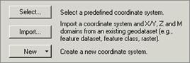
You have three options for
specifying the coordinate system for new feature classes and feature datasets.
· Select
When you select an existing coordinate system, you can
choose either a geographic or projected coordinate system. Because all
projected coordinate systems are based on a geographic coordinate system, you
set one or the other, never both.
ArcGIS supports over 600 geographic
coordinate systems, each optimized for a specific area on the earth, as well as
over 2,700 projected coordinate systems.
· Import
You can import a coordinate system from an existing
coverage, shapefile, feature class, or feature
dataset provided that the coordinate system has been documented for the source
data (for coverages, coordinate system information is
stored in a file called prj.adf; for shapefiles, this information is found in the .prj file). When you import a coordinate system, you have
the option of modifying its parameters.
· New
You can create a custom coordinate system by choosing the
desired parameters in a dialog. Your new coordinate system can be saved as a .prj file.
The
coordinate system that you specify when setting the spatial reference simply
documents your data—your data is not reprojected.
Therefore, if you accidentally set the wrong projected coordinate system when
creating a feature dataset, you can change it by choosing a different one in ArcCatalog.