Adding
data
After
you've created the structure of your geodatabase,
it's time to add the data. Just as there is more than one way to define the
structure, there is more than one way to add data to a geodatabase.
When you
import spatial data, you are creating the structure of a geodatabase
component and populating it with data at the same time. You can import one or
more data files at a time.
If you set
up the structure of your geodatabase by creating
empty feature classes, feature datasets, and nonspatial
tables, adding the data is a separate operation. You have several options for
adding data. You can:
· Use the Simple Data Loader in ArcCatalog
· Use the Object Loader in ArcMap
· Create new spatial data in ArcMap
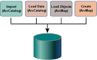
You can add data to a geodatabase using both ArcCatalog
and ArcMap.
Both the
Simple Data Loader and the Object Loader can be used to add data to an existing
feature class or table, which can either be empty or already contain data. The
Simple Data Loader allows you to add simple features and objects from multiple
sources into a single feature class or table, and the process is very quick.
The Object Loader allows you to load objects and their behavior, but the
process is slower.
In ArcMap, you can create new features when using geoprocessing tools, performing certain editing tasks, by
exporting selected features, as well as by digitizing. You'll learn about these
operations in the next lab.