Raster
data
How raster
data is handled depends on whether you are working with a personal geodatabase or an enterprise geodatabase.
In a personal geodatabase, raster data is referenced
rather than physically stored. In an enterprise geodatabase,
raster data is physically stored just like vector data.
With both
personal and enterprise geodatabases, you can view
and manage your raster data much as you would vector data.
There are
two types of raster objects that you can create in a geodatabase:
raster datasets and raster catalogs.
Raster
datasets
A raster
dataset is created from one or more individual rasters.
When creating a raster dataset from multiple rasters,
the data is mosaicked, or aggregated, into a single,
seamless dataset in which areas of overlap have been removed. The input rasters must be contiguous (adjacent) and have the same
properties, including the same coordinate system, cell size, and data format.
For each raster dataset, ArcGIS creates an ERDAS IMAGINE file (.img).
![]() Which raster formats are supported?
Which raster formats are supported?
Among the many raster formats supported by the geodatabase, you can create raster datasets from data
stored in the following formats:
· ERDAS IMAGINE
· ESRI GRID
· JPEG
· MrSID
· TIFF
Raster
datasets are always managed by the geodatabase. This
means that the .img files are stored in a separate
folder with the same name as the geodatabase. If the geodatabase is moved to another location, the folder
containing the .img files moves with it.
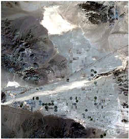
This raster dataset was created
from a single satellite image.
Raster
catalogs
A raster catalog contains a collection of rasters
that can be noncontiguous, stored in different formats, and have other different properties. In
order to view all the rasters in the catalog, they
must have the same coordinate system and a common geographic extent.
A raster
catalog is defined as a table in the geodatabase
which you can view like any other table in ArcCatalog.
Each raster in the catalog is represented by a row in the table.
You can
choose whether or not a raster catalog is managed by the geodatabase.
The geodatabase manages a raster catalog similarly to
the way it manages a raster dataset (it creates ERDAS IMAGINE files for each input
raster and stores them in a folder with the same name as the geodatabase).
If you
choose not to have the geodatabase manage the
catalog, the location on disk where the rasters are
stored will be recorded in the raster catalog table, but if the geodatabase is moved, the raster data will not move with
it.
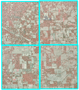
This raster catalog contains four rasters.
|
Table 2. Comparison of raster
datasets and raster catalogs |
|
|
Raster Dataset |
Raster Catalog |
|
Single
dataset built from one or more rasters |
Collection
of rasters |
|
Homogeneous
source data: same resolution, format, coordinate system |
Heterogeneous
source data: different resolutions, formats, data types, file sizes |
|
Faster
display |
Slower
display. The more rasters, the slower the display |
|
Loss of
overlapping pixels when mosaicked |
Overlapping
pixels are preserved |
|
One
metadata file |
Metadata
files for the catalog and for each raster |