Topology
In a
In a geodatabase, you can choose whether to create topology for
features. If your analysis will depend on accurately modeling spatial
relationships, creating topology is essential. For example, if you are modeling
a wastewater network, all the features must be connected or the results of any
analysis based on your model will be flawed. Or, if you are calculating the
total area for different types of land cover, gaps between land cover polygons
will result in inaccurate totals.
There are
three types of topology available in the geodatabase:
geodatabase topology, map topology, and the topology
created for a geometric network. A feature class can participate in only one
topology at a time.
Geodatabase topology
A geodatabase topology is a set of rules and properties that
defines the spatial relationships you want to model and preserve in your data.
ArcGIS includes over 20 topology rules from which you can choose. All feature
classes participating in a geodatabase topology must
be in the same feature dataset.
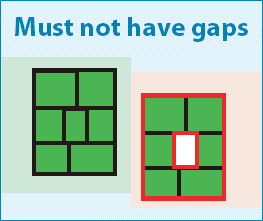
A geodatabase
topology rule applies to a particular type of spatial relationship. For
example, Must Not Have Gaps is a rule that defines a spatial relationship
between polygon boundaries.
To create
and edit a geodatabase topology, you need an ArcEditor or ArcInfo license.
Map
topology
A map
topology creates temporary topological relationships among features in one or
more feature classes during an edit session in ArcMap.
The ArcMap topology editing tools are used to
maintain these relationships while editing.
A map
topology can be created and edited using ArcView, ArcEditor, or ArcInfo. You'll
learn how to work with map topology in Lab 8.
Geometric
network topology
In a
geometric network, topological relationships are stored in the geodatabase and maintained automatically by the software.
In geodatabase and map topologies, spatial
relationships are not stored—they are "discovered" as needed (for
example, when a feature class is edited in ArcMap).
In a geometric network topology, topological relationships are established
between point and line feature classes stored in the same feature dataset.