Building
on the basics
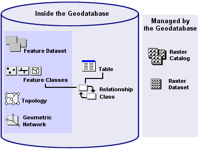
As you've
learned, the basic building blocks of a geodatabase
are feature classes, feature datasets, and nonspatial
tables. Using these, you can build more complex objects in your geodatabase. You can create associations among geodatabase components based on spatial relationships (topology)
or attributes (relationship classes). If you want to model the flow of
resources, such as water or electricity, you can build a geometric network.
Additionally, you can manage raster data using a geodatabase.
In this
topic, you will be introduced to these more advanced features of the geodatabase.
![]() Objects and the geodatabase
Objects and the geodatabase
As you work with a geodatabase
and read the documentation for it, you'll encounter terms like
"object" and "object class." If you're familiar with
object-oriented programming, you'll know what these terms mean. If you're not,
a little explanation is in order.
An object can be a house, a lake, a customer, or a
maintenance record. In the geodatabase, an object is
stored as a row in a table (called an object class). An object has a set of
attributes. Attributes describe an object, and could be its name, a measure, or
an identifier to another object. Objects can also have behavior. For example,
an object can participate in a relationship or be constrained by limits on
attribute values.
Object classes that store geometry are called feature
classes. Object classes that store relationships are called relationship
classes.
In addition to feature classes,
feature datasets, and tables, a geodatabase can
contain topology objects, geometric networks, and relationship classes. Raster
data is stored outside the personal geodatabase.