Nonspatial tables
You've
learned that the geodatabase is a relational
database. A relational database is composed entirely of tables. Most of these
tables are hidden from you when you work with a geodatabase
in ArcCatalog or ArcMap.
Your interaction with the tables is managed by the software. There are only two
types of tables that you interact with directly: feature class tables and nonspatial tables.
Both types
of tables are created and managed in ArcCatalog and
edited in ArcMap. Both display in the traditional
row-and-column format. The difference is that feature class tables have one or
more columns that store feature geometry.
Nonspatial
tables contain only attribute data (no feature geometry) and display in ArcCatalog with the table icon ![]() .
They exist in a geodatabase as standalone tables, and
they can be associated with other tables or feature classes. When a nonspatial table is associated with a feature class, you
can query, select, and symbolize features based on the data stored in the nonspatial table. You'll learn more about associating
tables in lab 9
.
They exist in a geodatabase as standalone tables, and
they can be associated with other tables or feature classes. When a nonspatial table is associated with a feature class, you
can query, select, and symbolize features based on the data stored in the nonspatial table. You'll learn more about associating
tables in lab 9
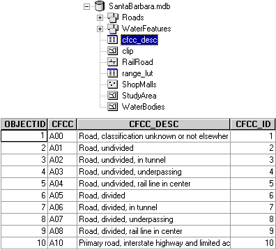
The cfcc_desc table in the SantaBarbara geodatabase contains attribute data for the Roads feature class (stored inside the Roads feature dataset).