Feature datasets
A feature
dataset contains a group of feature classes that share the same spatial
reference. That is, the feature classes must have the same coordinate system
and their features must fall within a common geographic extent.
Feature
datasets are primarily used to store feature classes that have topological
relationships, such as connectivity, adjacency, or containment. For example,
streams in a particular watershed are connected to rivers; therefore, streams
and rivers are topologically related.
In order for a geodatabase to maintain topological relationships among feature classes, the feature classes must reside in the same feature dataset. You'll learn more about topology in the next topic.
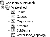
The five feature classes in the Watershed feature dataset have topological relationships that should be maintained when any of the feature classes are edited.