The basic geodatabase structure
A geodatabase
has three primary components—feature classes, feature datasets, and nonspatial tables. All three components are created and
managed in ArcCatalog.
· A feature class is a collection of
features that share the same geometry type (point, line, or polygon) and spatial
reference.
· A feature dataset is a collection
of feature classes. All the feature classes in a feature dataset must have the
same spatial reference.
· A nonspatial
table contains attribute data that can be associated with feature classes.
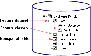
A geodatabase can contain feature classes, feature datasets, and tables of nonspatial data.