Creating
point features from tabular data
If you
have a file of tabular data that includes real-world coordinate locations, you
can bring that tabular data into ArcMap and create new point features from it.
Suppose
you are a biologist who has been out in the field taking water temperature
readings at different locations along a stream. You used a
An event
layer looks and acts like any other layer in the Table of Contents—you can turn
it on and off, symbolize it, and query it. However, features in an event layer
are not permanently stored on disk. They reside in your computer's memory and
can be saved only as part of the map document. To permanently save the point
features in an event layer, you can export the event layer to a geodatabase feature class or to a shapefile.
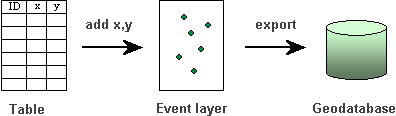
You can create point features by
adding x,y coordinates
stored in a table as an event layer to ArcMap. To permanently store the point
features on disk, you can export the event layer to a geodatabase
feature class.
You can
create an event layer from any kind of coordinates—latitude and longitude
coordinates (in decimal degrees) or x,y
coordinates. The x and y (or latitude and longitude) coordinates must be stored
in separate fields or separated by a delimiter such as a comma. Field names
cannot contain spaces, special characters, or dashes (e.g., x-coord).
When
adding the file to ArcMap, you specify the fields that contain the coordinates
as well as the coordinate system in which the data is stored.