Editing
made easier
Suppose
you're moving a street centerline feature that connects to another street
centerline feature at an intersection. No matter how carefully you use the
editing tools, you will likely have difficulty making the features connect at
precisely the right point. You may leave a tiny gap or an overlap between the
features.
To make
sure features connect properly with other features, you can use a method called
snapping. Snapping moves ("snaps") your mouse pointer exactly to a
vertex, edge, or endpoint of a feature when the mouse pointer comes within a
certain distance, called the snapping tolerance. The part of the feature to
which you can snap is called the snapping agent. You can designate the
vertices, edges, or endpoints of any existing layer as snap agents, and you can
turn snap agents on or off as needed.
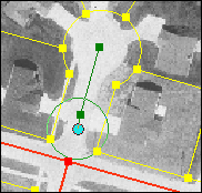
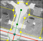
In the
example below, the yellow lines represent parcel boundaries and the red lines
represent streets. A new segment is being added to the streets layer. Snapping
has been turned on and the vertices of features in the streets layer have been
specified as the snap agents. The green circle represents the snapping
tolerance.
Mouse over the bullets below to see the effect of snapping using these
settings.
|
Before |
After |
|
|
|
|
Yellow lines represent parcel
boundaries; red lines represent streets. The green circle represents the
snapping tolerance. |
Because only the vertices of the
streets layer have been set as snap agents, the mouse pointer doesn't snap to
the vertices of features in the parcels layer even though they are within the
snapping tolerance. |