Raster
data formats
Two common
data formats based on the raster data model are grids and images.
Grids
Grids are
an ESRI file format used to store both discrete features such as buildings,
roads, and parcels, and continuous phenomena such as elevation, temperature,
and precipitation.
Recall
that the basic unit of the raster data model is the cell. Cells store
information about what things are like at a particular location on the earth's
surface. Depending on the type of data being stored, cell values can be either
integers (whole numbers) or floating points (numbers with decimals). There are two
types of grids: one stores integers and the other
stores floating points.
A discrete
grid contains cells whose values are integers, often code numbers for a
particular category. Cells can have the same value in a discrete grid. For
example, in a discrete grid of land use, each land use type is coded by a
different integer, but many cells may have the same code. Discrete grids have
an attribute table that stores the cell values and their associated attributes.
A
continuous grid is used to represent continuous phenomena; its cell values are
floating points. Each cell in a continuous grid can have a different floating
point value. For example, in a continuous grid representing elevation, one cell
might store an elevation value of 564.3 meters, while the cell to the left
might store an elevation value of 565.1 meters. Unlike discrete grids,
continuous grids don't have an attribute table.
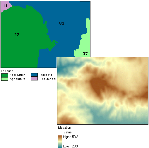
Discrete grids represent discrete
features such as land use categories with integer values. Continuous grids
represent continuous phenomena such as elevation with floating point values.
The
attribute tables of discrete grids are INFO format, the same format in which
coverage feature class attribute tables are stored. As with coverage attribute
tables, the INFO table of a discrete grid is stored within an info folder,
which is stored at the same level as the grid in a workspace folder. Again like
coverages, there is one info folder for all the grids
in a workspace folder. To avoid breaking or corrupting the connection between
grid files and the info folder, always use ArcCatalog
to move, copy, rename, and delete grids.
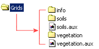
The Grids workspace folder contains
two grids: soils and vegetation. The attribute tables for both grids are stored
in the info folder. Auxiliary files called soils.aux
and vegetation.aux link the grids and their attribute
tables.
Images
The term
"image" is a collective term for rasters
whose cells, or pixels, store brightness values of reflected visible light or
other types of electromagnetic radiation, such as emitted heat (infrared) or
ultraviolet (UV). Aerial photos, satellite images, and scanned paper maps are
examples of images commonly used in a
Images can
be displayed as layers in a map or they can be used as attributes for vector
features. For example, a real estate company might include photos of available
houses as an attribute of a homes layer. To be displayed as a layer, however,
images must be referenced to real-world locations.
For
example, an aerial photo as it comes from the camera is just a static picture,
like a picture of a house. There's no information about what part of the world
the photo has captured, and the photo may contain distortion and scale
variations caused by the angle of the camera. To display properly with other
map layers, the aerial photo must be assigned a coordinate system and some of
its pixels must be linked to known geographic coordinates.
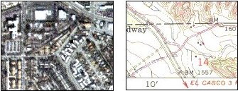
Raster images, such as aerial
photographs and scanned maps, can be referenced to real-world locations, then displayed as a layer in a
There are
many image file formats, which differ in the type of compression used to reduce
the file size. Some of the image formats supported by ArcGIS
software are .tif (Tagged Image File Format), .sid (LizardTech MrSID), .img (ERDAS Imagine), and
.jpg (Joint Photographic Experts Group).