Coverages
Coverages
are a file-based data format native to ESRI's ArcInfo® Workstation software. Conceptually, coverages can be thought of as a combination of other
vector data formats you have learned about.
Like a
feature class, coverages have a geometry type of
point, line, or polygon. And, also like a feature class, a
coverage represents a single thematic layer, such as schools, streets,
or land use, in which all features have the same attributes and are located
within a common geographic area.
On the
other hand, coverages are like a geodatabase
feature dataset because they store a set of spatially related feature classes.
Point, line, and polygon coverages each contain a
different set of feature classes that, together, define their features.
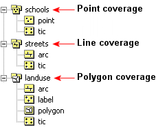
The geometry type of the coverage
determines which feature classes it will store.
![]() More about coverage feature classes
More about coverage feature classes
Coverages are a common data format, and you
may come across them in your organization or on the Internet. While there are
many, the main coverage feature classes are point, arc, polygon, label, and
tic.
· The point feature class stores the
point features of a point coverage.
· The arc feature class stores the
line features of a line coverage or the polygon
boundaries of a polygon coverage.
· The polygon feature class stores
the polygon features of a polygon coverage.
· The label feature class stores
points in the center of each polygon of a polygon coverage—these
points can be used to place feature labels.
· The tic feature class stores
geographic control points that represent known real-world coordinates. Tics are
used to reference coverage features to the real world. All coverages
have a tic feature class.
Coverages can contain many more types of
feature classes, including annotation, routes, and regions. For more
information about coverages and their feature
classes, refer to the ArcGIS Desktop Help (Contents
tab -> ArcCatalog -> Working with coverages).
The
attributes and spatial relationships associated with a coverage feature class
are stored in
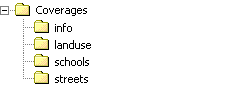
Here you see how coverages display in Windows Explorer. The Coverages workspace folder contains three coverages: landuse, schools, and
streets. The info folder contains the
By
default, in the ArcCatalog™ Catalog tree, you won't
see the info folder associated with a coverage, but
you can see it in your operating system's file manager (e.g., Windows
Explorer). You should never move, copy, rename, or delete a coverage using your
operating system's file manager since the connection between the coverage
feature classes and the info folder could become broken or corrupted. Always
use ArcCatalog to manage coverages.