The
geodatabase
The
geodatabase is a vector data format introduced by ESRI with ArcGIS® software.
In technical terms, the geodatabase is a relational database, a type of
database composed of various tables that organize data and are linked to one
another.
It may be
more helpful at this point, however, to just think of a geodatabase as a
container for storing geographic data. The geographic data stored in a
geodatabase may be point, line, or polygon feature classes as well as other
collections of data described below. The geodatabase has many powerful
capabilities for modeling real-world objects—you will learn more about it later
in this module.
How a
geodatabase organizes data
In
addition to point, line, and polygon feature classes, a geodatabase can store
annotation feature classes. Annotation is descriptive text about features or
areas on a map.
In the geodatabase,
feature classes can be standalone or they can be organized into larger units
called feature datasets. A feature dataset stores feature classes that have the
same coordinate system and the same spatial extent, meaning they occupy the
same geographic area. While all features in a feature class must have the same
geometry type, the same is not true for feature datasets. Feature datasets can
store feature classes with different geometry types.
Feature
classes grouped into a feature dataset normally have some kind of spatial
relationship to one another. For example, they might be adjacent, intersect
each other, or coincide with each other.
Feature
class tables store feature geometry and attribute information. Some attributes
in the feature class tables are automatically created and maintained by the
geodatabase. For line feature classes, the geodatabase automatically calculates
the length of each feature and stores that data in a field called Shape_Length.
For polygon feature classes, the geodatabase calculates the perimeter and area
of each feature and stores those values in fields called Shape_Length and
Shape_Area, respectively.
Sometimes,
for database efficiency (to speed up data queries and feature draw time),
feature attributes may be stored outside the feature class table in a separate
table. Geodatabase tables that contain only feature attributes—no geometry—are
called nonspatial tables.
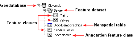
A geodatabase can contain
standalone feature classes, feature classes grouped into feature datasets,
annotation feature classes, and nonspatial tables.