What is a map projection?
map
projection is a method for converting the earth's three-dimensional surface to
a map's two-dimensional surface. A map projection can represent the earth's
entire surface or only a portion of it depending on your needs.
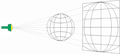
Map projections are so called because of the concept behind their construction rather than the actual methods used to create them. If you could project light from a source through the earth's surface onto a two-dimensional surface, you could then trace the shapes of the surface features onto the two-dimensional surface. This two-dimensional surface would be the basis for your map.
Cartographers use the term map projection to describe the process of converting coordinates from a three-dimensional spherical coordinate system to a two-dimensional planar coordinate system.
Although a
map projection gets its name from the idea of projecting a globe onto a flat
surface, map projections are actually created using mathematical formulas.
Don't worry, though—in this course, we'll let the