What is a coordinate system?
Imagine
yourself standing in a totally flat, featureless expanse where everyplace is the same as everyplace else. If someone asked,
"Where are you?" what would that mean? Where in relation to what?
Doesn't location assume a reference point?
This is the
problem—lack of orientation in space—that coordinate systems solve. They
establish the whereabouts of places by defining a starting point and a way to
measure distances and directions from that point.
The
starting point is called the origin of the system. On a flat surface, if you
have an origin, a distance measure of some kind (footsteps, for example), and a
way to fix your direction, you can describe locations uniquely.
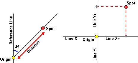
Two ways to
identify locations on a plane surface. Left: Draw a straight line (Reference Line)
through the origin. Draw another straight line from the origin to a point
(Spot). The angle between the two lines and the distance from Origin to Spot
identifies the point uniquely. Right: Draw two straight lines through the
origin that intersect each other at a 90-degree angle. Label the lines X and Y.
Sub-label them + and - on opposite sides of the origin. A point's location can
be uniquely identified by a distance from the origin parallel to X (+ or -) and
a distance from the origin parallel to Y (+ or -).
What if the
surface is not flat, but a sphere? The coordinate system is still based on an
origin and two lines intersecting at right angles, but points are not
identified in terms of surface distance. Instead, angles to the center of the
sphere are used.
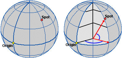
Left: The origin and a
location to be identified. Right: The X and Y lines still intersect at the
origin, but points are identified by interior angles of the sphere.