Transverse aspect
Rotating the cylinder 90 degrees in either direction places a cylindrical map projection in a transverse aspect. This puts the cylinder's tangent on a meridian or secants on lines that are parallel to meridians rather than on the equator. As a result, all other meridians and most parallels are represented as curved lines.
A Transverse Mercator map projection truncated at 75 degrees east and west from the Greenwich Prime Meridian.
North–south
distortion is less for a transverse cylindrical map projection, but distortion
increases quickly east and west from the central meridian. It is therefore
generally used for mapping regions with a more north–south orientation rather
than an east–west orientation.
Transverse cylindrical map projections wrap entirely around the earth from pole to pole. If you created a world map and unrolled it, the hemisphere opposite the central meridian would be displayed upside down. For this reason, transverse cylindrical map projections often only display the hemisphere containing the central meridian.
If you split a map at the south pole that used a transverse cylinder map projection and unrolled it, the opposite hemisphere would appear upside down.
Transverse
cylindrical map projections also have problems terminating. In a normal aspect,
the cylinder projection would never reach the north and south poles. Similarly,
in transverse aspect, a cylinder map projection will never reach 90 degrees
east and west from the projections central meridian. To overcome this,
transverse cylinder map projections terminate at specified east and west
meridians.
While the cylinder map projection's normal form is applied widely, although sometimes inappropriately, for mapping the world, the transverse form is more appropriate for mapping smaller areas and used more for planimetric mapping of local, state, or provincial features. The most common transverse cylinder map projection is the Universal Transverse Mercator map projection that is applied widely throughout the world.
More about the Transverse Mercator projection
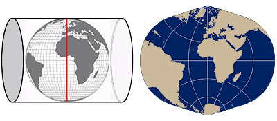
The Transverse Mercator map projection was invented by Johann Lambert and presented in 1772. Lambert rotated the Mercator cylindrical projection 90 degrees, making the tangent line a line of longitude instead of the equator. Only the central meridian and the equator of the projection are straight lines. All other latitude lines and longitude lines are complex curves; that is, they cannot be represented as sections of a single circle. Unlike the Mercator projection, the Transverse Mercator projection is not used on a global scale, but is applied to regions that have a general north–south orientation.
Feature distortion increases proportionally as the distance from the central meridian (the red vertical line) increases. For this reason, the Transverse Mercator map projection is applied to regions with a north-south orientation.
The Transverse
Mercator and specifically the Universal Transverse Mercator map projection and coordinate system, which divides the world into 36 six-degree longitudinal zones,
have both enjoyed considerable popularity around the world. In the