Tangents and secants
The plane
of a map projection is just another name for the surface of a map projection
and you will see it used throughout map projection documentation. There are
three developable surfaces, or two-dimensional geometric planes: the cone, the
cylinder, and the plane.
Imagine the
earth wrapped up in one of these developable surfaces. The line of contact
between the earth and this surface is called a tangent. If there are two
such lines, they are called secants. The contact point (or points)
between the spheroidal earth's surface and the plane
of the map projection is the only location where the properties of the
projection are true. It's important, therefore, to know exactly how and where
the plane of a map projection contacts the earth's surface since these tangents
or secants are lines of zero distortion on the map.
Now examine
a globe or imagine the earth as an object before you. You could look at it from
different points of view: straight on, sideways, from above, or from some odd
angle. In a map projection, these points of view are called aspects.
Some map
projections contact the earth's surface along a point or line, called a
tangent, while other map projections contact the earth's surface along two
lines, called secants. Both tangents and secants represent locations on the map
projection where there is no distortion. That is, there is no distortion of
shape, area, distance, direction, or scale. Features at these locations on the
projection are represented as they really are on the earth's surface.
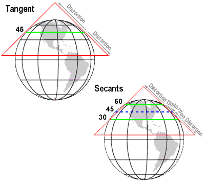
These examples show
tangent and secant conic map projections. As you move farther away from the
tangent or secant lines, distortion increases.
As you move
farther away from the tangent or the secants in either a northerly or southerly
direction, distortion increases. For a tangent map projection, this places the
center of the map on a line that does not exhibit any distortion. However, on a
map projection that uses secants, this causes the center of the map projection
to be located in a distortion zone. Although in a secant map projection the
center exhibits distortion, the distortion between the two secants is not the
same as that found in areas north and south of the secants and the overall map
projection's distortion is distributed more evenly for the area you are
mapping. In the next concept you will examine this in more detail.