Selecting secants
When you
choose a particular tangent for your map projection, you select it mainly
because it runs through the center of the area you need to map. Similarly, you
choose specific secants because they distribute the distortion evenly across
the area you need to map and place the center of the map between the two
secants. There are exceptions to these rules, which may involve organizational
mandates for standardization or the need to combine local data with regional
and national databases, but generally tangents and secants are chosen for the
reasons described.
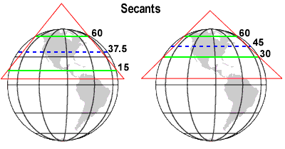
In the
graphics below, one conic projection uses 15°N and 60°N for its secants while
the other uses 30°N and 60°N. If you are mapping all of North America and
Central America, 15°N and 60°N might be appropriate choices; if you are mapping
only Canada, Mexico, and the United States, then 30°N and 60°N are more appropriate.
Why? Because you want to minimize the area distorted and the
amount of distortion.
The secants you choose
should be appropriate to your area. Your goal is to minimize distortion. For
maps of the continental
Look at the
area between the secants in the examples above. The example on the left
contains a much greater area than the one on the right. You can get a sense of
the distortion at the centers of each projection (represented by the dotted
blue lines) by seeing how much they extend beyond the conic plane to the
earth's surface. The greater the distance, the greater the
distortion.
Conic
projections are not the only projections that use secants. Cylindrical
projections also use them and for the same reasons: namely, to minimize and
distribute distortion.
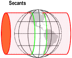
The most common
cylindrical projection that uses secants is the Universal Transverse Mercator. Here, the distance between the secants is greater
than it would be in a real projection.