Projection parameters
When you
choose a map projection, you mean to apply it either to the whole world or to
some part of the world—a continent, a strip of land, or an important point like
Redlands, California. In any case, you want the map to be just right for your
area of interest. “Just right” usually means having as little distortion as
possible, at least for the spatial property that you most want to preserve. And
sometimes it also means making sure that all the coordinates that mark
locations on the map have positive values.
You make
the map just right by setting projection parameters. Not all projections
have exactly the same set of parameters, though they tend to be similar. And
there are parameters that can be changed in some projections but not in others.
But, what it all comes down to is that parameters let you customize a
projection for your area of interest.
On the
round surface of the earth, locations are described in terms of latitude and
longitude. Some projection parameters, called angular parameters, are
set with these latitude-longitude values. Once the earth's back has been broken
with a projection, locations are described in terms of constant units like
meters or feet. Some projection parameters, called linear parameters,
use these constant units (or they use ratios, such as 0.5 or 0.9996).
Top: Round data is
described with meridians, parallels, and latitude-longitude values. Bottom:
Flat data is described with x,y
units. Projection parameters use both kinds of descriptions. The projection at
bottom is Plate Carrée.
Concepts
Angular parameters
·
Central meridian
·
Latitude of origin
·
Standard parallel
·
Latitude of center
·
Central parallel
Every
projection has a central meridian, which is the middle longitude of the
projection. In most projections, it runs down the middle of the map and the map
is symmetrical on either side of it. It may or may not be a line of true scale.
(True scale means no distance distortion.)
In ArcGIS,
you can change the central meridian of any projection. (Occasionally, it's the
only angular parameter you can change.)
The central
meridian is also called the longitude of origin or the longitude of
center. Its intersection with the latitude of origin (see below) defines
the starting point of the projected (x,y)
map coordinates.
Every
projection also has a latitude of origin.
The intersection of this line with the central meridian is the starting point
of the projected coordinates. In ArcGIS, you can put the latitude of origin
wherever you want for most conic and transverse cylindrical projections. (In
many world projections, on the other hand, it is defined to be the equator and
can't be changed.) The latitude of origin may or may not be the middle latitude
of the projection and may or may not be a line of true scale.
![]() More about the latitude
and longitude of origin
More about the latitude
and longitude of origin
The important thing to remember about the latitude and
longitude of origin is that they don't affect the distortion pattern of the map.
All they do is define where the map's x,y
units will originate.
When data is unprojected, it
doesn't have x,y units.
Locations are measured in latitude and longitude, as you know from the previous
module. But when you set a projection and flatten everything out, you also
start using a new way to measure location. This new way is in terms of constant
distance units (like meters or feet) measured along a horizontal x-axis and a
vertical y-axis. A location like x = 500,000, y = 100,000 would refer to a point
500,000 meters (or whatever units of measure you are using) along the x-axis
and 100,000 meters along the y-axis. The place where the axes cross is the
coordinate origin, or 0,0 point. Commonly, this is in
the middle of the map but it doesn't have to be.
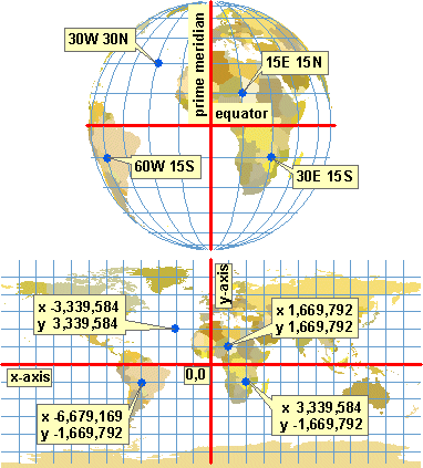
In the top graphic below, the intersection of the central
meridian (longitude of origin) and the latitude of origin is
marked with a cross. This point becomes the origin of the x,y coordinates.
Top: The point of
intersection of the central meridian and latitude of origin becomes the origin
of the x,y coordinates.
Bottom: Red lines represent the x and y axes.
The bottom graphic shows the grid (normally invisible) on
which the x,y coordinates
are located. The heavy lines are the x- and y-axes, which divide the grid into
four quadrants. Coordinates are positive in one direction and negative in the
other for each axis.
In essence, a map projection is a method for taking
locations on a sphere, as defined by the intersection of a meridian and a
parallel, and assigning them to locations on a grid, as defined by the
intersection of an x-axis and a y-axis.
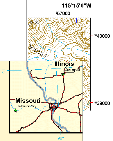
Often, you don't care where the x,y coordinates originate, but sometimes, on published
maps that have locational reference marks, you want
all the reference marks to have positive values. You can help make this happen
by setting the latitude of origin below the area of interest, ensuring that all
y-coordinates on the map are positive. (The same result can be achieved with
false northing, discussed in the next concept).
A standard
parallel is a line of latitude that has true scale. Not all projections
have standard parallels, but many common ones do. Conic projections often have
two. In a few projections, like the Sinusoidal and the Polyconic,
every line of latitude has true scale and is therefore a standard parallel.
In ArcGIS,
you can change the standard parallel for some projections and not for others.
Many world projections, for instance, have fixed standard parallels. (These do
not show up as parameters when you set the projection, but you can find out
what they are in the online help.)
A standard
parallel may or may not coincide with the latitude of origin.
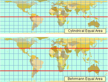
Top: The Cylindrical
Equal Area projection has a single standard parallel. By default, it is the
equator, but you can change it. Bottom: The Behrmann
projection is the same projection, but with two standard parallels at 30° N and
30° S. These standard parallels define the projection and cannot be changed.
In some
projections, you will also see parameters called the latitude of center
and the central parallel. These two terms seem to have the same meaning.
Like the latitude of origin, they define the starting point of the
y-coordinates; unlike it, they are nearly always the middle parallel of the
projection. These parameters are used mainly with projections that have single
points (rather than lines) of zero distortion, such as the Gnomonic and
Orthographic. The intersection of the latitude of center (or central parallel)
with the central meridian defines both the origin of the x,y coordinates and the point of zero distortion for
the projection.
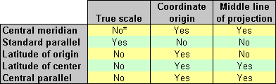
A
summary of angular parameters. "Yes" means yes; "no" only
means not necessarily. For example, the standard parallel may be the
y-coordinate origin and the middle latitude of the projection, but it doesn't
have to be. (* In transverse cylindrical projections, the central meridian does
have true scale by definition.)
Other
angular parameters are used only with a few specific projections, like the Two
Point Equidistant and the Hotine Oblique Mercator. For example, the Hotine
Oblique Mercator has special parameters for defining
an oblique line of true scale. You used these parameters in a previous
exercise.
Linear parameters
·
False easting
·
False northing
·
Scale factor
Projected
coordinates (that is, x,y
coordinates) are positive for some map locations and negative for others,
depending on where the x- and y-axes intersect. But on published maps that use x,y coordinates as reference
marks, it is standard practice to have all coordinates positive.
This may
happen with no effort on your part (if your area of interest is favorably
located). Or you may be able to make it happen through your choice of central
meridian and latitude of origin. Another way to make it happen, and a
convenient one, is by the use of false easting and false northing
values. These are nothing but two big numbers that are added to each x- and y-coordinate,
respectively. The numbers are big enough to ensure that all coordinate
values—or at least all those in your area of interest—come out positive.
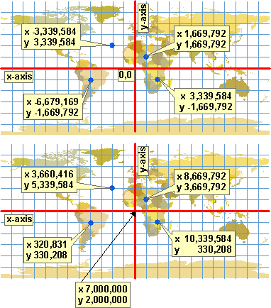
Top: Projected
coordinates are positive or negative, depending on their location. Bottom: A
false easting value of 7,000,000 and a false northing value of 2,000,000 have
been set. Every x-coordinate is now its original value plus 7,000,000. Every
y-coordinate is its original value plus 2,000,000. The projection is Plate Carrée.
You might
be asking yourself when you should show x,y
values on a map instead of latitude-longitude values. The answer is related to
scale. Small and medium-scale maps normally use latitude-longitude values,
while larger scales use x,y
values. It's also common to see both types of values on the same map.
Details
of two maps. Lower left: An Albers Equal-Area Conic projection of the
northeastern
![]() Reference marks and map
scale
Reference marks and map
scale
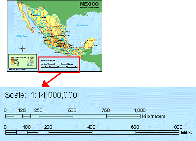
Distance units (projected coordinate values) are typically
used for reference at scales larger than 1:10,000, while latitude-longitude
values are used at scales smaller than 1:1,000,000. At intermediate scales,
both are frequently shown. (Maling, 1992)
Map
projections in the Universal Transverse Mercator and
State Plane Coordinate Systems (which you will learn about in Module 5, Geographic
and Planar Coordinate Systems) have conventional false easting and false
northing values, which are applied by default in ArcGIS.
A scale
factor is the ratio of the true map scale to the stated map scale for a
particular location. Remember that no map has true scale everywhere.
![]() More about true scale
More about true scale
The scale text or scale bar that is printed on a map is
correct only for lines of true scale. For instance, on a map with standard
parallels, the stated map scale will be correct for measurements along those
parallels, but not for measurements along other parallels, meridians, or
oblique lines.
A map
of
For large-scale maps and maps with good distance-preserving
properties, you won't go too far wrong making measurements in any direction.
But with some projections (such as the Mercator) at
small scales, distance measurements can be significantly wrong if you are not
on or near a line of true scale. Sometimes you will see maps with stacked scale
bars that show the correct scale for different lines of latitude on the map.
A line of
true scale is defined as having a scale factor of 1.0. Along this line, the
actual map scale is equal to the stated scale (there is no distortion of
distance). A scale factor of 2.0 means that distance measurements on the map
are twice too long—if your scale bar tells you it's a
hundred kilometers from A to B, it's really only fifty kilometers. A scale factor of 0.5 means that distance measurements are twice
too short.
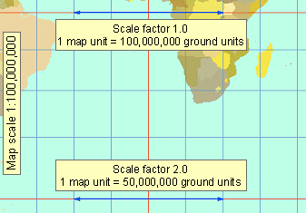
A Mercator
projection with a stated map scale of 1:100,000,000. Along a line of true
scale, such as the equator in this projection, the scale factor is 1.0. One map
unit equals the number of ground units that the map says it does. At 60° north
or south, the scale factor increases to 2.0 along the parallels. The blue
double-headed arrow at the bottom of the map measures only half as much ground
as the one at the top.
In ArcGIS,
a scale factor can be applied to the line of true scale for transverse and
oblique cylindrical projections and a few others. Changing the scale factor of
this line creates two parallel lines of true scale on either side of it. (In
other words, it gives the projection two secant lines instead of one tangent
line.) The purpose is to balance distortion within the area of interest.
For
Universal Transverse Mercator projections, the
default scale factor is 0.9996. For other projections, it is 1.0.
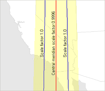
The yellow shaded area
is covered by the Universal Transverse Mercator
projection for Zone11North. The central meridian has a scale factor of 0.9996.
This setting creates two parallel lines of true scale on either side of the
central meridian. The result is a better balancing of distortion within the
zone.