Planar projections
Planar projections, also called azimuthal
projections, project map data onto a flat surface. The simplest planar
projection is tangent to the globe at one point. Although the point of contact
may be any point on the earth's surface, the north and south poles are the most
common contact points for most
When the plane touches the earth at either the north or south poles, longitude lines converge at the point of contact and radiate outward from the pole at their true angle like the spokes on a wheel, the distance between them increasing as the distance from the contact point increases. Latitude lines appear as a series of concentric circles.
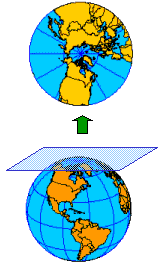
This particular map projection's light source originates at the center of the earth, but this is not true for all planar map projections.
Because
area and shape distortion are circular around the point of contact, planar
projections accommodate circular regions better than rectangular regions. For
this reason, they are used most often to map polar regions.
In the
polar form, longitude lines passing through the point of contact are
represented by straight lines and directions from the point of contact are
accurate.
Some planar
map projections, such as the example above, represent all great circles as
straight lines. Because the shortest distance between two points on the globe
is a great circle, or a portion of a great circle, the shortest distance
between two points on this type of projection is also a straight line. This
makes planar map projections that maintain this trait extremely useful for
plotting navigational routes for airplanes.
Later in this course, you will learn how light source positions, also called perspective positions, play an especially important role in planar projections. You will also learn how different aspects, such as polar, equatorial, or oblique, affect the map projection.