Equatorial (normal) aspect
You are already familiar with the equatorial, or normal, aspect cylindrical map projection, although you may not know it, because it was used in Module 2, Flattening the Earth, to explain the concept of a cylindrical map projection. In the normal aspect, the cylinder, or its surface plane, is parallel to the earth's axis. This causes all latitude lines to be parallel and all longitude lines to be parallel. As a result of this, latitude lines and longitude lines meet at right angles.
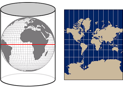
This Mercator map projection decreases the distance between parallels as they approach the north and south poles in an attempt to help compensate for extreme scaling and truncates at approximately 84 degrees north and south when distortion becomes extreme.
You learned
in Module 2 that normal aspect cylindrical map projections, if left
uncorrected, result in extreme scale distortions in northerly and southerly
locations, but less distortion in east–west locations.
In addition, if left uncorrected, normal aspect cylindrical map projections would continue forever because the projected light from the center of the earth through the poles is parallel to the cylinder's sides and so would never intersect it. Because of this, most cylindrical map projections truncate or have some mathematical method for ending the map projection when the distortion becomes extreme enough that the map projection fails to be useful.