Early mapmakers
When the
ancient mapmakers first began representing the earth's surface on a map, they
simply drew geographic features as they saw them or as travelers and explorers
described them.
Because so
little was known about the world, information on maps was rather sparse and it
was difficult to evaluate a map's quality or accuracy. In fact, most maps
created before the European Renaissance were so generalized and inaccurate that
the mapmakers could have assumed we lived on a flat earth and it wouldn't have
made the slightest difference to the map's usefulness.
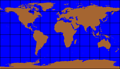
One of the earliest, if not the first, map projection was the plane chart, or Plate Carrée. Invented around the first century CE (Common Era), it treated the graticule as a grid of equal squares, forcing meridians and parallels to meet at right angles.

This is an example of a modern Plate Carrée map projection that maintains true scale only along the equator.
The Plate Carrée map projection was soon modified by Marinus of Tyer (around 100 CE). Marinus' projection is similar to the Plate Carrée except the graticule is represented by rectangles instead of squares.
This is a modern example of an equidistant map projection. The squares of the Plate Carrée have been replaced by rectangles.
Perhaps the
most famous of the pioneering mapmakers was Claudius Ptolemy (125 CE), whom you
may remember from Module 1, Sizing Up the Earth.
He pioneered the use of curving parallels and converging meridians on maps.
Ptolemy's maps were "
More about Ptolemy
Ptolemy, or
Claudius Ptolemaeus, was a Greek who lived in the
intellectual center of the second century CE—
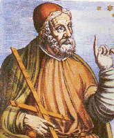
Ptolemy is regarded as
the father of geography and his influence was felt well into the European
Renaissance period.
Ptolemy's
contributions to astronomy, geography, and cartography are considerable. He is
generally known for advancing the basic principles of science, introducing the
use of latitude and longitude on maps as a reference system, introducing or
improving several map projections, and for his support of an earth-centered
universe.
Although
the maps at the time were usually so imprecise that the application of any locational system was suspect, the use of latitude and
longitude was still an important step forward in mapmaking. His contributions
to map projections are considerable. Some scholars claim that it was Ptolemy
that actually introduced the concept of map projections to the world. Before Ptolemy,
the concept was an esoteric construct known only to a few mathematicians and
philosophers.
In cartography, he is best known for three map projections. The first projection employed straight meridians that converged at the poles and curved parallels—qualities of a simple conic projection. The second projection would be classified today as a pseudoconic projection. It has curved evenly-spaced parallels and curved meridians that converge at the poles. His third projection would be classified today as an azimuthal projection. It resembled a modified perspective view of the earth, but there is little, if any, evidence that he actually used it.
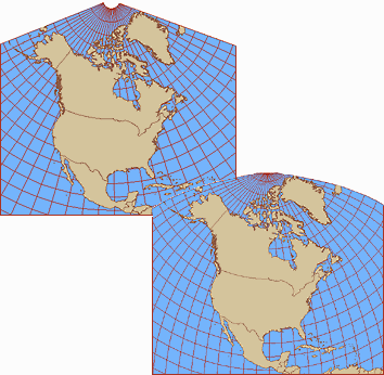
The upper left projection is a simple conic projection that demonstrates the properties of Ptolemy's first projection. The lower right map projection is a modern Bonne projection that demonstrates some of the characteristics of Ptolemy's second projection. Notice the curved meridians.
Ptolemy
published his findings in two works. One is titled Almagest (Arabic for
"The Greatest") and the other is simply titled Geography. The
latter appears, at least in part, in some 39 editions ranging from Greek and
Latin to Arabic and English.
Ptolemy was
a great geographic personality and his errors were also great. It was Ptolemy
who declared that the heavens revolved around the earth and that the earth was
the center of the universe. (Of course, that mistake didn't originate with
him.) The earth-centric view dominated both science and theology for fourteen
centuries. It is said that Christopher Columbus relied on Ptolemy's calculation
of the earth's circumference (28,985 kilometers or 18,000 miles) to decide that
he could reach