Distance
An
equidistant map preserves the property of distance. Another way to say this is
that the map has true scale. But wait, this has to be qualified.
Consider a
map with a stated, or nominal, scale of 1:100,000. You might naturally assume
this means than a measurement of 1 unit on the map is equal to 100,000 units on
the earth. In fact, that is what it means—but on most maps it's only true of a
few special lines, such as standard parallels.
Even on an
equidistant map, true scale is not possible for all lines. Back in Module 2,
you learned that an equidistant map preserves true scale for all lines passing
through (or radiating from) a single, specific point.
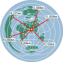
An Azimuthal
Equidistant projection centered on
True scale for more than one point
The Two-Point Equidistant projection maintains true scale
for all lines that pass through either of two points, such as
The term
“equidistant” is also applied to other projections that maintain true scale
along all meridians.
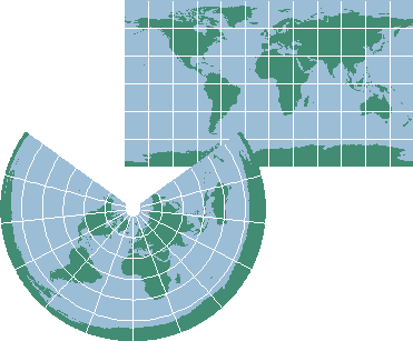
Top: An Equidistant
Cylindrical projection. Bottom: An Equidistant Conic projection. Both correctly
measure the distance from pole to pole (about 20,000 kilometers) along each
meridian.
There are
also projections that maintain true scale the other way—along all parallels.
The Sinusoidal is one example and the Polyconic is
another. But these projections are not considered equidistant.