Conic projections
Conic
projections are
created by setting a cone over a globe and projecting light from the center of
the globe onto the cone. Ptolemy's maps used many conic projection
characteristics, but there is little evidence that he actually applied the cone
or even referred to a cone as a developable map projection surface. Johannes Ruysch was probably the first person to apply what we would
recognize as a true conic projection in 1507.
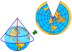
The simplest conic projection contacts the globe along a single latitude line, a tangent, called the standard parallel. Longitude lines are projected onto the conical surface, meeting at the apex, while latitude lines are projected onto the cone as rings. The cone is cut along any longitude line to produce the final projection. The meridian opposite the cut is the map projection's central meridian (the red line in the graphic below). The resulting map has straight converging longitude lines with the distance between them widening as their distance from the apex increases and concentric circular arcs for latitude lines.
The Simple Conic projection is also called the Equidistant Conic projection.
In general,
distortion increases north and south of the standard parallel. Distortion at
the poles is so extreme that many maps that use conic projections remove the polar regions. Conic projections are typically used for
mid-latitude zones with an east–west orientation. They are normally applied
only to portions (such as
Later in the course, you will learn more about central meridians, tangents, secants, and standard parallels, and about how their selection affects the projection.